Port-Christmas
Considered to be a safe haven, in the 19th century it regularly welcomed the ships of seal and whale hunters, mainly from Nantucket, who scoured the southern seas and islands.
Descriptions of these landscapes by explorers in their travelogues inspired great writers, starting with Edgar Allan Poe (1838), followed by Jules Verne (1897), who incorporated them into their adventure novels, then Valery Larbaud (1933) and Jean-Paul Kaufmann (1993), among others, in their more personal works.
The name "Port-Christmas" was established by Raymond Rallier du Baty in 1908 to designate the most isolated part of Baie de l'Oiseau, as shown on the 1⁄228000 map published in 1922.
[3] This now-official toponymy puts an end to almost two centuries of debate between the name given to the whole bay by Kerguelen, "Baie de l'Oiseau", and the one chosen by Cook, "Christmas Harbour".
However, when France decided to reaffirm its sovereignty by sending the French aviso ship l'Eure in 1893 to perform a new take-over ceremony, Baie de l'Oiseau formally reverted to its original name.
In the end, the current consensus, instituted by Rallier du Baty, which "semi-francizes" Christmas Harbour as Port-Christmas and reserves its denominations for a particular area of Baie de l'Oiseau, allows us to respect Kerguelen's former discovery while preserving the historical trace of Cook's passage.
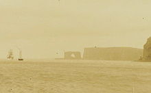
The geological environment of Port-Christmas, like that of practically the entire Loranchet Peninsula, is dominated by trap-rocks, terraced basaltic piles formed by the superimposition of lava outpourings[11] around twenty-eight to twenty-nine million years ago.
The beach drop-offs at Port-Christmas are notable for their abundance of soft corals (Onogorgia nodosa), and the giant seaweed Macrocystis pyrifera forms dense seagrass meadow.
While early records describe a verdant, albeit short and treeless, coastal landscape covered with grasses (Gramineae), azorella, and Kerguelen cabbage, the colonization of the entire main island by rabbits has since led to a considerable weakening of plant formations, which are often reduced to a meager meadow of Acaena magellanica.
Generally speaking, the fauna and flora are in accordance with that to be found in Baie de l'Oiseau and more widely on the main island of the archipelago, known as La Grande Terre.The entire Port-Christmas area is part of the Réserve naturelle nationale des Terres australes françaises,[22] which, since 2019, has been classified as World Heritage under the name of "French Southern and Antarctic Lands".
The area is closed to the introduction of any new animal or plant, any disturbance of living communities, any industrial, commercial or mining activity, and any biological or mineral extraction, with the exception of rare exemptions that may be granted by the Reserve's management or for scientific research purposes.
During the few days la Dauphine was separated from the group, Ferron du Quengo, commander of the Corvette, spotted the entrance to a bay around December 20th, 1773, but was unable to gain entry.
The ship's surgeon, William Anderson, noted both the presence of Kerguelen cabbage (Pringlea antiscorbutica), which could be used to combat the scurvy[nb 3] often suffered by crews on long voyages, and the abundance of "oil resources".
»The expedition set off again on December 31 to explore the surrounding eastern coasts all the way to the present-day Gulf of Morbihan, which James Cook named "Royal Sound".
[25] In 1840, British explorer James Clark Ross anchored at Port-Christmas for 68 days, between May and July,[8] as part of a major scientific expedition around the world and towards the poles, with the primary objective of studying geomagnetism.
[6][8][27] Ross's mission brief included a long series of other physical observations to be carried out: meteorological, oceanographic, hydrographic, as well as a naturalistic component to which the expedition's surgeons, Robert McCormick, Joseph Dalton Hooker and David Lyall, made a major contribution by exploring from Christmas Harbour.
[6] Consequently, at the suggestion of the Boissière brothers, President Sadi Carnot decided to send the Eure, an aviso french ship under the captaincy of Commander Louis Édouard Paul Lieutard (1842–1902) [nb 6], to solemnly repossess the Austral Islands on behalf of France.
The French military, reiterating the takeover made 120 years earlier on the same spot, proceeded ashore to raise the colors on the mast and affix a copper plaque engraved "EURE – 1893".
[6][25] Returning from an oceanographic expedition to the outskirts of Antarctica, German marine biologist Carl Chun arrived in Port-Christmas aboard the Valdivia in 1898, where he declared himself fascinated by the "romanesque" character of the place.
[27][31] In December 1964, the replacement ship, the Gallieni,[32] brought a team to Port-aux-Français to carry out tellurometer measurements and helicopter overflights to produce a general map of the archipelago.
Poe accurately describes the natural harbor and the typical arch,[36] sometimes repeating almost verbatim[37] the description given by seal-hunting captain Benjamin Morrell in A Narrative of Four Voyages, published in 1832.
Without ever having been there, the French novelist gives a precise geographical description and establishes a fictitious cosmopolitan settlement of around twenty inhabitants centered around Fenimore Atkins, the proprietor of the Au Cormoran-Vert inn, living off the seasonal staging of English and American sealers and whalers.
Navigator and travel writer Raymond Rallier du Baty docked at Port-Christmas in 1908 to map the archipelago and wrote a literary description in his story On peut aller loin avec des cœurs volontaires.
[39] He humorously proposes the following rules:"... 'You have had the misfortune to displease those in high places; but in deference to your merits, we have contented ourselves with distancing you by appointing you for one ... three ... five years (that's a maximum) Governor of (sic) Kerguelen, with residence at Port-Noël, the main town of this colony.
French sailor Isabelle Autissier, after a dismasting in 1994 that forced her to make reparations in Port-aux-Français, published a literary biography in 2006, Kerguelen, le voyageur du pays de l'ombre, in which she describes in detail the arrival of the crew of L'Oiseau in the homonymous bay in January 1774, and the onshore takeover led by Messieurs de Rochegude and du Cheyron,[42] based on available historical data (diaries and accounts) and her own experience of the site.
Grandiose indeed, but in the manner of a funerary monument when the shine of smooth marble evokes eternity... " – Isabelle Autissier, 2006.At least five TAAF stamps featuring the Port-Christmas location or its immediate surroundings were issued,[43][44] the first three engraved by Pierre Béquet :