Port Jackson
The location of the first European settlement and colony on the Australian mainland, Port Jackson has continued to play a key role in the history and development of Sydney.
Thus, many botanists, see, e.g., Robert Brown's Prodromus Florae Novae Hollandiae et Insulae Van Diemen,[1] described their specimens as having been collected at Port Jackson.
[4] At the time of the European arrival and colonisation, the land around Port Jackson was inhabited by the Eora clans, including the Gadigal, Cammeraygal, and Wangal.
Cook named the inlet after Sir George Jackson, one of the Lords Commissioners of the British Admiralty, and Judge Advocate of the Fleet.
[6] As the Endeavour sailed past the entrance at Sydney Heads, Cook wrote in his journal "at noon we were...about 2 or 3 miles from the land and abrest of a bay or harbour within there appeared to be a safe anchorage which I called Port Jackson."
On 21 January 1788, after arriving at Botany Bay, Governor Arthur Phillip took a longboat and two cutters up the coast to sound the entrance and examine Cook's Port Jackson.
In his first dispatch from the colony back to England, Governor Phillip noted that:[7][8] We got into Port Jackson early in the Afternoon, and had the satisfaction of finding the finest Harbour in the World, in which a thousand Sail of the line may ride in the most perfect security...I fixed on the one [cove] that had the best spring of Water, and in which the Ships can Anchor so close to the Shore, that at a very small expence...Port Jackson was described as a "capacious harbour, equal, if not superior to any yet known in the world", that "sheltered anchorage for the ships" and provided "a suitable landing place on rocks on the western side of the cove, relatively level land at the head of the cove, and a run of fresh water", in addition to it being "capable of affording security to a much larger fleet than would probably ever seek for shelter or security in it."
Royal Navy officer David Blackburn also described it as a "fine Harbour as Any in the World, with water for any Number of the Largest ships.
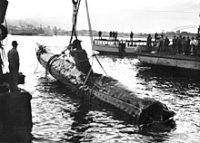
On the night of 31 May 1942, three Japanese midget submarines entered the harbour, one of which became entangled in the western end of the boom net's central section.
[12] Fort Denison is a former penal site and defensive facility occupying a small island located north-east of the Royal Botanic Garden in Sydney Harbour.
[17] Exposed at low tide is Sow and Pigs Reef, a well-known navigation obstacle near the main shipping lane.
Due to its exposed proximity to the Tasman Sea, it is slightly cooler, wetter and windier than Observatory Hill to the west.
In addition to featuring the lowest maximum summer temperatures in the Sydney region (averaging just 24.4 °C (75.9 °F)), Port Jackson is also least affected by extreme heat due to frequent sea breezes.
Sydney Cove, a bay in Port Jackson's west side that includes Circular Quay, is more proximate to the Observatory Hill weather station, and therefore the climate data below does not apply to that vicinity.
[26] White Bay and adjacent Glebe Island have been working ports since the mid-1800s, handling just about everything from timber and paper, coal, sugar and cement to cars and containers.
The NSW Government identified both as vital to the City's economy and in March 2013 announced its commitment to maintaining both as working ports as it frees up neighbouring bays for public access.
Glebe Island is Sydney's last remaining deepwater port able to supply the City's ongoing demand for dry bulk goods such as sugar, gypsum and cement.
[28] RAN Heritage Centre at Garden Island has many exhibits, artefacts and documents relating to the history of the Royal Australian Navy.
[33] Port Jackson has a number of heritage-listed sites, including: A Sydharb is a unit of volume used in Australia for water, especially in dams and harbours.