Port Way
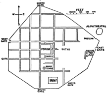
Port Way[1] (also known as the Portway)[2][a] is an ancient road in southern England, which ran from Calleva Atrebatum (Silchester, in modern-day Hampshire) in a south-westerly direction to Sorbiodunum (Old Sarum, Wiltshire).
By the time of the Roman occupation of Calleva Atrebatum and Sorbiodunum, the road formed part of a longer route between Londinium (London) and Isca Dumnoniorum (Exeter).
The section east of Hannington in Hampshire, however, has not been definitively traced in over 100 years and sources differ on the precise route into the Roman town at Calleva Atrebatum.
[2][20][21] Beyond St Mary Bourne, near Finkley and East Anton, Port Way was crossed by Margary route 43, the road from Venta Belgarum to Cunetio (Mildenhall)[2][22] sometimes described as being part of the Icknield Way.
[31] Contrary to Hoare's belief that this was the site of Vindomis, the discovery of the Calleva Atrebatum to Noviomagus Reginorum (Chichester) road led to the consensus that the settlement was in the area of present-day Neatham near Alton.
[37] Quarley Hill provided a line-of-sight with Sorbiodunum,[27] and from here the road took a south-west heading through the Bourne Valley into present-day Wiltshire, crossing the river between Winterbourne Gunner and Gomeldon.
[11] Both Calleva Atrebatum and Sorbiodunum are listed in Iter XV of the Antonine Itinerary, although the distance given between the two towns – 55 Roman miles[e] – is via Vindomis and Venta Belgarum rather than a straight route along Port Way.
[2][11] Further west, close to the Amesbury branch railway in the parish of Newton Tony, a section of the road in excellent preservation was carefully examined; Margary noted that both here and at Bradley Wood, the agger was 27 feet (8.2 m) wide.
[42] In 1851, Henry MacLauchlan reported that the route could not be distinguished from Calleva Atrebatum until the area of Wolverton and Ewhurst, where farmers could occasionally observe the effects of the road in their cornfields.
[47] In the St Mary Bourne area, the route occasionally dictates or influences field boundaries,[48] and at Middle Wyke, the Finkley Road follows its course into East Anton.
"[11] Archaeological excavations have found evidence of Roman villas along the Portway corridor at Balchester,[52] Abbotts Ann,[53] Grateley,[54] Hurstbourne Priors,[55] and Allington.