Port au Port Peninsula
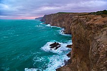
The geological structure is complex, with the peninsula's sedimentary strata dating to the middle Cambrian to early Ordovician continental margin, creating a carbonate platform of limestone, shale, and sandstone.
Mi'kmaq families, who came from Nova Scotia with the French to fight the British in the Thirty Years' War, were also present in the area.
Additionally, the area's strong Roman Catholic tradition is reflected in the high visibility accorded to churches throughout the peninsula's communities.
As the centre of the province's Franco-Newfoundlander community, the peninsula has been designated the only bilingual district on the island of Newfoundland since 1971.
Beginning in 1900, a limestone quarrying operation was established at Aguathuna, near the peninsula's isthmus, where the Table Head mountain ridge extends from the Lewis Hills.
Geologists have estimated that a much larger deposit exists deeper and possibly off shore from the peninsula in the 400-500 billion barrel range; however, exploration drilling has not yet confirmed this theory.
[9][10][11][12][13] A Canadian energy company may soon get the green light to begin drilling for oil off Newfoundland's southwest coast.
The Canadian Imperial Venture Corporation (CIVC) is waiting for approval from the federal-provincial oil regulator – the Canada Newfoundland and Labrador Offshore Petroleum Board – to drill a test well on Shoal Point, near the Port Au Port Peninsula.
[14] Today travellers access the area using the Marine Atlantic ferry service to Channel-Port aux Basques[15][16] or with the Stephenville International Airport.