Port of Singapore
In the late 13th century, a Kingdom known as Singapura was established on the north bank of the Singapore River around what was called the Old Harbour.
First, it made available products that were in demand by international markets; according to the Daoyi Zhilüe (Brief Annals of Foreign Islands, 1349)[4] by Chinese trader Wang Dayuan (born 1311, fl.
[6] In 1984, an archaeological excavation had commenced at Fort Canning Hill led by the archaeologist Dr John Miksic.
A range of artefacts including earthenware, ceramic, and porcelain pieces were found which suggests Singapore's role as an active trading port in the 14th century.
[7][8] By the 15th century, Singapore had declined as an international trading port due to the ascendance of the Malacca Sultanate.
A map of Singapore by Portuguese mathematician Manuel Godinho de Eredia showed the location of Xabandaria or the office of a shahbandar, the Malay official responsible for international trade.
Shards of 15th-century Siam ceramics and late 16th – or early 17th-century Chinese blue and white porcelain have been found at the Singapore and Kallang Rivers.
For instance, blackwood (a generic term used by Europeans to refer to rosewood) was exported from Singapore to Malacca, and was in turn purchased by Chinese traders and shipped to China for furniture-making:) In the early 17th century, Singapore's main settlement and its port were destroyed by a punitive force from Aceh.
Singapore had also supplanted Tanjung Pinang as the export gateway for the gambier and pepper industry of the Riau–Lingga Archipelago by the 1830s, and South Johor by the 1840s.
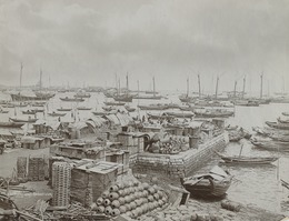
[6] As the volume of its maritime trade increased in the 19th century, Singapore became a key port of call for sailing and steam vessels in their passage along Asian sea routes.
Roads and railways were developed to transport primary materials such as crude oil, rubber and tin from the Malay Peninsula to Singapore to be processed into staple products, and then shipped to Britain and other international markets.
[6] By the 1980s, maritime trading activity had ceased in the vicinity of the Singapore River except in the form of passenger transport, as other terminals and harbours took over this role.
[citation needed] Singapore is part of the Maritime Silk Road that runs from the Chinese coast to the southern tip of India, to Mombasa, from there through the Red Sea via the Suez Canal to the Mediterranean, to the Upper Adriatic region of the northern Italian hub Trieste with its rail connections to Central Europe and the North Sea.
[19] Singapore is ranked first globally in 2005 in terms of containerised traffic, with 23.2 million Twenty-foot equivalent units (TEUs) handled.
A rise in regional traffic consolidating the port's position in Southeast Asia, and increases in transshipment traffic using the strategic East Asia-Europe route via Singapore helped the port to emerge tops at the end of the year, a title it had not held since overtaking Hong Kong once in 1998.