Porthcurno
Road access is via the north end of the valley along a long cul-de-sac with short branches off the B3283 and land traditionally associated with the village, including its beach, is on the South West Coast Path.
[3] A low-frequency bus service links Penzance, Lands End and nearby villages and hamlets including Newlyn, Paul, Sheffield, Lamorna, St Buryan, Treen, Trethewey, Polgigga and Sennen.
In most local-level organisational and community bodies, it is in civil and ecclesiastical parishes named Saint Levan and usually spelled as St Leven since the 18th century.
[5] Porthcurno was chosen in preference to the busy port of Falmouth because of the reduced risk of damage to the cables caused by ships' anchors.
[5] In 1950 the latter, nationalised, opened its Porthcurno engineering college which provided many courses in branches of telecommunications for employees, secondees and external students.
The cable office at Porthcurno was a critical communications centre and considered at serious risk of attack during the Second World War, being only about 100 miles (160 km) from the port of Brest in occupied France.
[11][12] To improve security, a network of two parallel tunnels, connected by two smaller cross-tunnels, was bored into the granite valley east side by local tin mining labourers, starting in June 1940, to accommodate the essential telegraph equipment.
[13] Each of the main tunnel interiors was that of a windowless open-plan office constructed as a building shell within the granite void, complete with a pitched roof to collect water seepage from the rocks, a false ceiling, plastered and decorated walls, and all the necessary services.
[14][15] The concrete defences around the tunnel entrances and the nearby buildings were camouflaged with the help of a local artist: the design, when viewed from the air with some imagination, resembled a belt of trees, complete with rabbits and birds.
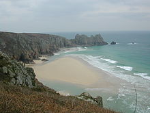
[22][23] The nearby cliffs rise to 60 m to 70 m above mean sea level and are formed from a bedrock of prismatic granite; over the geological timescales having been eroded, shaped and divided vertically and horizontally sometimes almost into rounded cubic blocks.
[2][3][24][25] An ancient bridleway, probably an early route to Porthcurno beach via the nearby Trendrennen Farm, about half a mile to the east of the village, has been opened by the Ramblers Association.
[citation needed] Porthcurno Beach and Bay, a few hundred yards south of the village is situated in the shelter of the Logan Rock headland just less than one mile (1.6 km) to the east.
About halfway along the main coastal footpath from Porthcurno to Logan Rock another path loops off to the cliffs above Pedn Vounder beach.
[35] Such was the disgust of the local people at this blatant act of vandalism, that they complained to the Admiralty and Goldsmith was ordered to replace the rock at his own expense.
The original invoice for equipment and labour is now displayed on the wall of The Logan Rock public house in the nearby village of Treen.
In common with much of the south Cornish coast, summer daily maxima rarely exceed about 25 degrees Celsius (77 °F) and below-freezing temperatures and frost are uncommon.
For the more exposed cliff-top areas, gale-force winds are common throughout the year which occasionally cause moderate structural damage to buildings locally.
[41] In the Cornish language 'porth kornow / porth cornow' (standard written form uses "c") meant 'cove/landing place of horns or pinnacles', a reference to the granite rock formations in the vicinity.
[citation needed] During the Second World War, Porthcurno was designated a Vulnerable Point and was heavily defended and fortified as a part of British anti-invasion preparations.
The theatre is accessible on foot from the coastal footpath by a rugged path in the cliff face or more easily by road taking the steep narrow hill leaving Porthcurno to the south towards St. Levan Church and turning left at the top.
[1] Here, exposed areas of granite bedrock and concrete plinths retain the preserved remains of the base and guy wire tether points of a wireless telegraphy antenna mast that was erected in 1902 by the Eastern Telegraph Company.
[51][52] It was thought that this was used to 'spy' on the early wireless transmissions by Marconi, a developer of radio, from the Poldhu cliff top about 17 miles (27 km) to the east, across Mount's Bay on the west side of the Lizard Peninsula.
Marconi's secretive development of the Shortwave Beam Wireless System at Poldhu would be so successful that Eastern and many other cable telegraph companies were forced into near-bankruptcy by 1928.
The British philosopher Bertrand Russell, his wife Dora and their children John and Kate spent the summer months from 1922 to 1927 in Porthcurno.