Possession Islands
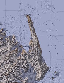
The Possession Islands (71°56′S 171°10′E / 71.933°S 171.167°E / -71.933; 171.167) are a group of small islands and rocks extending over an area of about 7 nautical miles (13 km; 8.1 mi), lying in the western part of the Ross Sea, lying 5 nautical miles (9.3 km; 5.8 mi) south-east of Cape McCormick, in Victoria Land, Antarctica.
The Possession Islands were named by Captain James Clark Ross, Royal Navy, in commemoration of the planting of the British flag here on January 12, 1841.
[1] A 276 ha (680 acres) site comprising the whole of Possession Island has been designated an Important Bird Area (IBA) by BirdLife International because it supports about 111,000 breeding pairs of Adélie penguins, based on ground counts made from 1981 to 2012.
A small peak, 100 metres (330 ft) high, at the north end of Foyn Island.
Named by US-ACAN for Lieutenant Commander John W. St. Marie, United States Navy, co-pilot on the Squadron VX-6 flight of Jan. 18, 1958, at which time the Possession Islands and this feature were photographed.
Named by US-ACAN for Robert D. Favreau, USMC, Navigator on the United States Navy Squadron VX-6 flight of Jan. 18, 1958, at the time this feature was photographed.
Twin rocks lying 1 nautical mile (1.9 km; 1.2 mi) south of Possession Island.
[12] This article incorporates public domain material from websites or documents of the United States Geological Survey.