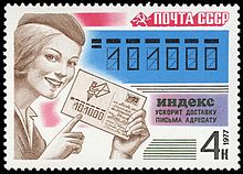
Postal code
By World War I, such postal district or zone numbers also existed in various large European cities.
By 1930 or earlier, the idea of extending the postal district or zone numbering plans beyond large cities to cover even small towns and rural locales had started.
Modern postal codes were first introduced in the Ukrainian Soviet Socialist Republic in December 1932,[4] but the system was abandoned in 1939.
The next country to introduce postal codes was Germany in 1941,[5] followed by Singapore in 1950,[6] Argentina in 1958, the United States in 1963[7] and Switzerland in 1964.
The letter combinations "SS" (Schutzstaffel), "SD" (Sicherheitsdienst), and "SA" (Sturmabteilung) are not used, due to links with the Nazi occupation in World War II.
The Canadian Postal Codes use alternate letters and numbers (with a space after the third character), formatted ANA NAN.
Andorra, Azerbaijan, Barbados, Ecuador, Latvia and Saint Vincent and the Grenadines use the ISO 3166-1 alpha-2 as a prefix in their postal codes.
In New Zealand, Auckland, Wellington and Christchurch were divided into postal zones, but these fell into disuse, and have now become redundant as a result of a new postcode system being introduced.
Some postal code systems, like those of Ecuador and Costa Rica, show an exact agreement with the hierarchy of administrative divisions.
Format of six digit numeric (eight digit alphanumeric) postal codes in Ecuador, introduced in December 2007: ECAABBCC Format of five digit numeric Postal codes in Costa Rica, introduced in 2007: ABBCC In Costa Rica these codes were originally used as district identifiers by the National Institute of Statistics and Census of Costa Rica and the Administrative Territorial Division, and continue to be equivalent.
The first two digits of the postal codes in Germany define areas independently of administrative regions.
The coding space of the first digit is fully used (0–9); that of the first two combined is utilized to 89%, i.e. there are 89 postal zones defined.
Parks, large businesses such as shopping centers and big houses, may have more than one entrance and more than one delivery point.
In 2004–2006, there were some efforts in Slovakia to reform the system, to get separate post codes for every district of single postmen, but the change was not realized.
The format of the PIN is ZSDPPP defined as follows: The first digit represents nine total zones: eight regional and one functional.
The first three digits are the routing key, which is a postal district and the last four characters are a unique identifier that relates to an individual address (business, house or apartment).
For example, the Irish Parliament Dáil Éireann is: D02 A272 Postal codes in the Netherlands, known as postcodes, are alphanumeric, consisting of four digits followed by a space and two letters (NNNN AA).
The structure is alphanumeric, with the following six valid formats, as defined by BS 7666:[16] There are always two halves: the separation between outward and inward postcodes is indicated by one space.
Extremely large organisations such as larger government offices or bank headquarters may have multiple postcodes for different departments.
There are 121 postcode areas in the UK, ranging widely in size from BT which covers the whole of Northern Ireland to WC for a small part of Central London.
Postcode areas occasionally cross national boundaries, such as SY which covers a large, predominantly rural area from Shrewsbury and Ludlow in Shropshire, England, through to the seaside town of Aberystwyth, Ceredigion on Wales' west coast.
The first three numbers identify a specific sectional center facility—or central sorting facility—that serves a geographic region (typically a large part of a state).
Although using the ZIP+4 offers higher accuracy, addressing redundancy, and sorting efficiency within the USPS, it is optional and not widely used by the general public.
The British Crown Dependencies of Guernsey, Jersey and the Isle of Man are part of the UK postcode system.
Approximately one million letters come in to Santa Claus each Christmas, including from outside of Canada, and all of them are answered in the same languages in which they are written.
[23] Canada Post introduced a special address for mail to Santa Claus, complete with its own postal code: In Belgium bpost sends a small present to children who have written a letter to Sinterklaas.
They can use the non-geographic postal code 0612, which refers to the date Sinterklaas is celebrated (6 December), although a fictional town, street and house number are also used.
As of January 2010[update], the United Kingdom Government is consulting on whether to waive licensing fees for some geographical data sets (to be determined) related to UK postcodes.

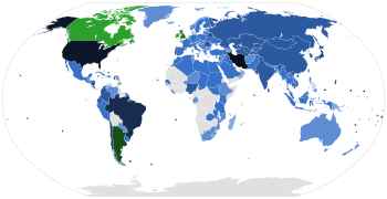
Numeric digits :
3 4 5 6 7 8 9 10
Alphanumeric digits : 6 7 8
Postal codes not in use :


