Presque Isle State Park
With the growing importance of shipping on Lake Erie in the 19th century, Presque Isle became home to several lighthouses and what later became a United States Coast Guard station.
[2] The Presque Isle peninsula formed on a moraine from the end of the Wisconsin glaciation and is constantly being reshaped by waves and wind.
[5] The earliest known inhabitants of the southern Lake Erie coast were the Erielhonan, also known as the "Eriez", an Iroquoian speaking tribe of Native Americans.
[6][7] An Erielhonan legend taught that the Great Spirit led them to Presque Isle because of the wealth of game, the abundance of clean fresh water, and the cool breezes "coming from the land of snow and ice" (i.e. Canada).
Despite initial victories over the Senecas, in 1654 the Erielhonans' largest village, Rique (at the modern city of Erie), was destroyed by 1,800 Iroquois warriors.
[8] The British constructed a new fort of the same name that year, which later fell to Native American forces on June 19, 1763, during Pontiac's Rebellion.
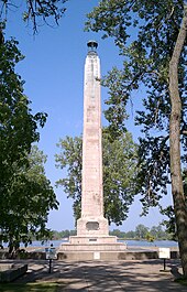
[2][5][12] After the Battle of Lake Erie on September 10, 1813, Perry's two largest ships were badly damaged, and the US Brig Lawrence was intentionally sunk in Misery Bay.
In 1858, a stronger steel structure was brought from France and installed at Erie to replace the wooden beacon, which had been damaged by a schooner.
Today the lighthouse is maintained by the United States Coast Guard and flashes a white light to warn ships of the sandy peninsula that juts into Lake Erie.
In 1917 a pumphouse powered by a steam engine was built: this pumped the water from one basin into the other, then across Presque Isle Bay to Erie.
[25] A recommendation was made to abolish the independent board as early as 1930, although this did not come about until January 19, 1971, with the creation of the state Department of Environmental Resources (which later became the DCNR).
Rated EF0 on the Enhanced Fujita Scale, it downed power lines and trees near the Stull Interpretive Center, and also damaged a nearby observation platform.
[32] Presque Isle is a recurved sand spit formed during the last glacial period, or ice age, when the Laurentide Ice Sheet advanced into the basin now occupied by Lake Erie, and, when it retreated to the north between 12,370 BC and 12,790 BC, left behind a moraine consisting of clay, sand, and gravel which initially formed the peninsula.
[35] In the 1950s, in an effort to combat erosion, the state and federal governments built sets of concrete seawalls and perpendicular groins.
[39] According to the DCNR, because it has so "many unique habitats, Presque Isle contains a greater number of the state's endangered, threatened and rare species than any other area of comparable size in Pennsylvania".
The ponds start as trapped pockets of lake water and can erode away or be filled by wind-blown sand or drifting dunes.
[44] The new ponds provide habitat for plants and animals: for example, the state park is home to 89 species of Odonata (dragonflies and damselflies) and Lepidoptera, including 35 different butterflies, as well as 84 different sorts of spiders.
[42] The sixth and seventh ecological zones are characterized by their shrubs and trees, and Presque Isle State Park is home to 633 plant species (195 monocotyledons, 410 dicotyledons, 5 gymnosperms, 5 horsetails, 13 ferns, and 5 mosses).
If left undisturbed, this ecological succession is believed to take between 500 and 600 years, although visitors to parts of Presque Isle State Park can walk through all of these zones in 5 miles (8 km).
Forty-five of the bird species found in the park are listed as "endangered" or "threatened", including the piping plover, cerulean warbler, rusty blackbird and saltmarsh sharp-tailed sparrow.
The majority of collection during the annual Christmas Bird Count, which has been held in Erie County since 1956, is garnered from observations made by volunteers within the park.
[48] Many different species of plants and animals can also be found at Presque Isle State Park due to the wide variety of ecological zones.
Excavations such as those to make the waterworks basins or the marina have destroyed habitats, but yearly artificial replenishment with sand helps to create new ones.
[24] Presque Isle lies on the Atlantic Flyway, a major migratory path, and some of these birds migrate from as far north as the Arctic Circle to South America.
Without new sand, erosion has reduced the northern beaches of Gull Point, even while regions to the east and south have continued to grow at a slower rate, for a net yearly loss of 0.4 acres (0.2 ha).
TREC is named for former Pennsylvania Governor Tom Ridge, "who grew up in Erie, worked at the park as a young man and provided funding for the center and numerous Presque Isle projects during his administration".
[51] Facilities at the 65,000-square-foot (6,000 m2) Tom Ridge Environmental Center include eight research laboratories (including several large aquariums) for the RSC, several classrooms, a "Discovery Center" for younger students to explore science hands-on, interpretive exhibits highlighting local and regional flora and fauna, as well as the human history and culture of the area.
Boating, canoeing, fishing, and water skiing are common summer sports, while hiking, biking, inline skating, and bird watching are some of the inland activities.
Scuba divers must be certified and are required to register at the park office to obtain information on the waters that are open to diving.
Presque Isle Bay is the home of muskellunge, northern pike, crappie, smelt, as well as other fish that swim in from the lake.