Preston, Minnesota
[4][5] The Root River runs through it, and Mystery Cave State Park is nearby.
It was built around 1890 for holding grain for shipment by railroad to the Eastern cities of the United States.
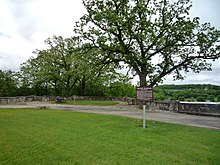
The Preston Overlook was built in 1937 by the Minnesota Department of Highways under the program of Federal Relief Construction during the New Deal.
A site was chosen on the highest point on the bluffs above the Root River, 90 feet below.
The Preston Overlook was listed on the National Register of Historic Places in 2003.
According to the United States Census Bureau, the city has a total area of 2.45 square miles (6.35 km2), all land.
36.3% of all households were made up of individuals, and 16.6% had someone living alone who was 65 years of age or older.
32.9% of all households were made up of individuals, and 15.8% had someone living alone who was 65 years of age or older.
Preston is intersected by the Harmony-Preston Valley segment of the Blufflands State Trail.