Prince Rupert, British Columbia
[4] Prince Rupert replaced Port Simpson as the choice for the Grand Trunk Pacific Railway (GTP) western terminus.
[5] It also replaced Port Essington, 29 km (18 mi) away on the southern bank of the Skeena River, as the business centre for the North Coast.
[7] Kaien Island, which comprised damp muskeg overlaying solid bedrock, proved expensive both for developing the land for railway and town use.
[8] By 1909, the town possessed four grocery, two hardware, two men's clothing, a furniture, and several fruit and cigar stores, a wholesale drygoods outlet, a wholesale/retail butcher, two banks, the GTP Hotel and annex, and numerous lodging houses and restaurants.
Although he never visited Canada, it was named after Prince Rupert of the Rhine, the first Governor of the Hudson's Bay Company, as the result of a nationwide competition held by the Grand Trunk Railway, the prize for which was $250.
The GTP also planned a large hotel, the Château Prince Rupert, connected to a railway station and passenger ship pier, all of which went unbuilt.
[13] Charles Melville Hays, president of the GTP, whose business plan made little sense, was primarily responsible for the bankruptcy of the company, and the establishment of a town that would take decades to achieve even a small fraction of the promises touted.
After the attack on Pearl Harbor, the Canadian government planned to level off Mount Hays, the largest mountain to the southeast of the city, to allow for a potential airstrip due to its tactical location and advantage.
Prince Rupert was considered the halibut capital of the world from the opening of the Canadian Fish & Cold Storage plant in 1912 until the early 1980s.
[17][18] A long-standing dispute over fishing rights in the Dixon Entrance to the Hecate Strait between American and Canadian fisherman led to the formation of the 54-40 or Fight Society.
In 1946, the Government of Canada, through an order in council, granted the Department of National Defence the power to administer and maintain facilities to collect data for communications research.
The 1949 Queen Charlotte earthquake, with a surface wave magnitude of 8.1 and a maximum Mercalli intensity of VIII (severe), broke windows and swayed buildings on August 22.
The years from 1996 to 2004 were difficult for Prince Rupert, with closure of the pulp mill, the burning down of a fish plant and a significant population decline.
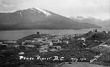
[23] Prince Rupert is on Kaien Island (approximately 770 km (480 mi) northwest of Vancouver), just north of the mouth of Skeena River, and linked by a short bridge to the mainland.
[28] Winters in Prince Rupert are mild by Canadian standards, with the average afternoon temperature in December, January and February being 5.2 °C (41.4 °F), which is the tenth warmest in Canada, surpassed only by other British Columbia cities.
Winters are chilly and damp, but warmer than most locations at a similar latitude, due to Pacific moderation: The January daily mean is 2.4 °C (36.3 °F), although frosts and blasts of cold Arctic air from the northeast are not uncommon.
A belief at the beginning of the 1900s that trade expansion was shifting from Atlantic to Pacific destinations,[62] and the benefit of being closer to Asia than existing west coast ports, proved wishful.
[64] During 1906–08, the federal government undertook a hydrographic survey of the Prince Rupert harbour and approaches, finding it free of rocks or obstructions, and sufficient depth for good anchorage.
Much of the harbour is formed by the shelter provided by Digby Island, which lies windward of the city and contains the Prince Rupert Airport.
Finally, the extremely mountainous nature and narrow channels of the surrounding area leaves Prince Rupert as the only suitable port location in the inland passage region.
Access to the airport is typically achieved by a bus connection that departs from downtown Prince Rupert (Highliner Hotel) and travels to Digby Island by ferry.
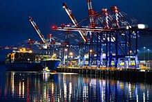
Freight traffic on the Prince Rupert mainline consists primarily of grain, coal, wood products, chemicals, and as of 2007, containers.
Running during daylight hours to allow passengers to be able to see the scenery along the entire route; the service takes two days and requires an overnight hotel stay in Prince George.
The new corporation immediately purchased the local cable company, Monarch Cablesystems, expanding CityWest's customer base to other northwest British Columbia communities.
[80] Prince Rupert is a central point on the Inside Passage, a route of relatively sheltered waters running along the Pacific coast from Vancouver, British Columbia to Skagway, Alaska.
Due to the Passenger Vessel Services Act of 1886, many cruise ships visit during the summer en route between Alaska to the north and Seattle and the Lower 48 to the south.
Prince Rupert is also the starting point for many wildlife viewing trips, including whales, eagles, salmon and grizzly bears.
The Khutzeymateen Grizzly Bear sanctuary features one of the densest remaining populations in North America; tours can be arranged by water, air (using float planes) or land departing from Prince Rupert.