Accursed Mountains
It is the southernmost subrange of the 1,000-kilometre-long (621 mi) Dinaric Alps range (Dinarides), extending from northern Albania to western Kosovo and northeastern Montenegro.
According to one local legend, the devil escaped from hell and created the jagged glacial karsts in a single day of mischief.
[4][5] The Accursed Mountains, the southernmost part of the Dinaric Alps, stretch more than 60 kilometres (40 mi) from Lake Skadar along the Montenegrin–Albanian border in the southwest to Kosovo in the northeast.
[citation needed] From Lake Skadar, the mountains stretch northeast along the Cem river then curve slightly to the east in the direction of Gjeravica summit above the western Kosovo (450m) basin.
The Accursed Mountains finish in the area of upper Ibar River valley near Mitrovica, just after the Suva Planina (1,750 metres (5,740 ft)) massif that encircles Dukagjin basin from the north and northwest.
[citation needed] The Accursed Mountains are ethnographically and sociologically diverse with many tribes living in the region as sheep herders.
Names of various Albanian tribes (Hoti, Gruda, Kelmendi, Kastrati, Dukagjini, Shkreli, Shala, Nikaj, Krasniqi, Gashi, Kuci and Rugova) refer to their geographical locations within the range.
The route is called "Prvo Koplje" and its first ascent was made by the alpinists Žarko Gostović (1950-2019) from Skopje, Macedonia and Ante Bedalov (1952-1974) from Kaštel Kambelovac, Croatia.
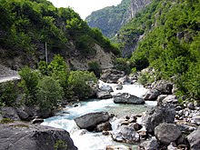
Overhanging walls and ridges forming pointed peaks are typical of the western and central Accursed Mountains.
This tectonic crash produced the unusual zig-zag shape of the range and also their curving from the dominant Dinaric northwestern – southeastern direction toward the northeastern one.
[8] In the western and central parts of the range the composition of the mountains is of mainly uniform with Mesozoic limestones and dolomites of the Jurassic and Cretaceous ages.
The south wall of the Maja Harapit is 800 metres (2,600 ft) high, making it the highest rock face on the Balkan Peninsula.
Many lakes are in the Bogiçevica border area between Kosovo and Albania and the Buni i Jezercë trough near the Jezerca and Bojs peaks.
In the Pleistocene period this was a collection area for ice that fell down over steps of rock from surrounding peaks, dragging with it heterogeneous material.
The lake lies at an altitude of 906 m (2,972 ft) above sea level in the Plav valley, nestled between the Accursed Mountains and the Visitor range.
A recent report from geographers at the University of Manchester details the discovery of four previously unknown glaciers in the Albanian part of the mountain range at 1980–2100 m high, found in the area close to Maja e Jezerces.
Glacier-climate modeling suggests that these glaciers require annual accumulation of between 4,137 and 5,531 mm (162.9 and 217.8 in) (rainfall equivalent) to balance melting, which would correspond to between 49.7 and 66.4 metres (163.1 and 217.8 ft) of snow.
The geographers think at least eight glaciers were present in neighbouring mountains[clarification needed] during the 19th century, correlating with the culmination of the Little Ice Age in the European Alps.
[15] The vegetation of the Accursed Mountains is among the richest on the Balkan Peninsula and one of the main central European regions for flora.
[citation needed] Because of its altitude and its favored habitat, the range is one of the centers of arcto-alpine relict flora of the Balkan Peninsula.
Aspens (Populus tremula) grow in damp sites alongside mountain maple (Acer pseudoplatanus) and Norway spruce (Picea abies).
The flora in the rocky areas of the Accursed Mountains are particularly noteworthy, because they are rare rich and endemic species, including the Tertiary relic Amphoricarpos neumayeri.
A plantain (Plantaginaceae) is found in the central Accursed Mountains as a variant of the alpine Wulfenie, but 700 km away it does not grow.
Viola chelmea is a violet species that occur on the Montenegrin-Albanian border area, especially at the lake Bukumirsko Jezero at 2,100 meters, and are only found on Asia Minor and the Balkans where they can grow due to woody, robust rhizome, cleistogamous flowers, and a lack of foothills.
All the large mammals including wolves, chamois, foxes, badgers and wild boar are hunted without regard to national park boundaries.
[33] The Montenegrin part of the mountain range was declared Prokletije National Park in 2009, comprising an area of 16,000 ha (62 sq mi).
At the edges there are some settlements: the Albanian Koplik and the Montenegrin Tuzi in the west near the Skadar Lake; Plav and Gusinje in of the northern valley of the upper Lim river in Montenegro and Bajram Curri, the main town of the district Tropoja, in the eastern part of the mountain range.
Even the somewhat more distant, larger cities of Shkodra, Podgorica, Gjakova and Peja create their sphere of influence and are frequently visited by inhabitants of the highlands for errands, administrative procedures and market sales.
[21] In addition to the seasonal migration, the whole mountain area is suffering from a severe "brain drain", as its income from agriculture is low.
The road from Qafa Thores leading to Theth has been recently paved with crash barriers and guard rails added, but is still steep, winding and narrow in places.