Province of Brandenburg
During the Migration Period, they were succeeded by the Polabian Slavs, whose fortress at Brandenburg an der Havel was conquered by the German king Henry the Fowler in 928/29.
Henry subdued the Slavic tribes up to the Oder river and his son Otto I established the marca Geronis on their territory, with the government first conferred to the Saxon count Gero.
[2] Over the centuries, the Hohenzollerns gradually rose to one of the most important dynasties of the Empire, rivalling with the ruling House of Habsburg, a process that intensified with the Protestant Reformation and the inheritance of the Polish Duchy of Prussia in 1618.
The margraviate formed the core of the Brandenburg-Prussian state and the "Great Elector" Frederick William I made various accessions to the territory, the Treaty of Königsberg of 1656 marking a significant turn in its evolution.
The margraviate remained a constituent part of Prussia, until after the Napoleonic Wars and the 1815 Congress of Vienna the kingdom's administration was divided into ten provinces.
The Province of Brandenburg also encompassed the territory of Lower Lusatia (where Cottbus had been a Brandenburgian exclave since the 15th century) as well as the area around Belzig and Jüterbog, all annexed from the Kingdom of Saxony for her alliance with Napoleon.
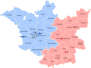
The Province headed by an Oberpräsident was subdivided into two governorates (Regierungsbezirke) named after their respective capitals, Potsdam in the northwest (Mittelmark, Prignitz and Uckermark) and Frankfurt (Oder) in the southeast (Neumark and Lower Lusatia).
The large estates had to deal with low soil quality and—except for brown coal occurrences in Lower Lusatia—the lack of natural resources.
The provincial life was perpetuated in the novels by Theodor Fontane and especially in his 1862–89 descriptive work Wanderungen durch die Mark Brandenburg.
After the Machtergreifung on 30 January 1933, the Nazi Gauleiter Wilhelm Kube held the office of the Oberpräsident, succeeded by Emil Stürtz in 1936.
[7][8] In the late days of World War II it was the site of the bloody encounters of the Seelow Heights, at Halbe and finally the Battle of Berlin, won by the Soviet and Polish armies.
Since 1875, with the strengthening of self-rule within the provinces, the urban and rural districts (Kreise) elected representatives for the provincial Landtage diets.