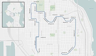
Queen Anne Boulevard
The local community club approached the Parks Board to propose a scenic route ringing the hill.
The proposed route was not part of the then recently developed "Olmsted Plan" for Boulevards and Parkways, and the proposed route along standard city streets did not seem to offer the 150-foot (46 m) width that had been established as a standard for boulevards, to allow park-like landscaping.
This combination of roadway and park, vistas and improved transportation to privately owned land, was not a complete success.
Parks and Engineering continue each to have responsibilities relative to the boulevard, resulting in occasional inter-departmental squabbling.
The race runs clockwise, starting near the Mt Pleasant Cemetery and finishing at Coe Elementary School.