Querétaro
[12] Querétaro is located in the north-central area of Mexico, or the Sierra Madre Oriental, connecting the wetter climes of the south with the drier deserts of the north.
They range from near desert conditions to forests of pine and holm oak to the tropical rainforests of the Huasteca area in the state of San Luis Potosí.
This area is managed by la Comisión Nacional de Áreas Naturales Protegidas of the Secretariat of Environment and Natural Resources federal agency.
[15] El Semidesierto Queretano (Querétaro Semidesert) is a wide strip that crosses the state from east to west, which is dry due to the blocking of moist air from the Gulf by the Sierra Madre Oriental.
This area occupies the municipalities of Ezequiel Montes, El Marqués, Pedro Escobedo and San Juan del Río with an extension of 2,480.2kmw or 21.1% of the state.
This dry area includes the municipalities of Querétaro, Corregidora, El Marqués, Peñamiller, Esequiel Montes, Cadereyta, San Juan del Río, Tolimán and Tequisquiapan.
Mesquite forests are scarce given that they tend to grow on land suitable for agriculture, but some can still be found in Pedro Escobedo, San Juan del Río, Cadereyta de Montes and other municipalities.
[10] The Cerro del Cimatario, on the borders of the municipalities of Corregidora, Querétaro and El Marqués, has been declared a national park and biosphere reserve due to its forests.
For men, this includes shirts and pants of undyed or white cotton, tied with an embroidered belt, huaraches and a hat made with palm fronds.
[20] In the Sierra Madre Oriental, about 3,775 people, mostly Pame with an important group of Huastecas are found in three communities in the municipalities of Jalpan de Serra and Arroyo Seco.
[26] Western painting developed in the state during the colonial period, when artists such as Pedro de Rojas López, Tomás Noriega and Diego Sanabria produced primarily religious art.
The current generation of Querétaro artists includes Rafael Rodríguez, Virginia Ledesma, Ramsés de la Cruz and Juan Eduardo Muñoz .
The current generation of writers includes poets Román Luján, Luis Alberto Arellano, Benjamín Moreno, César Cano and Tadeus Argüeyo.
[24][38] The Spanish and their indigenous allies were battling the local Otomi and Chichimecas at a hill now known as Sangremal, which was then called Ynlotepeque, and considered sacred in pre-Hispanic times.
Chronicles of this event, such as those written by Friar Isidro Félix de Espinoza, state that the natives were at the point of winning when a total eclipse of the sun occurred.
From the 16th to 19th centuries The Spanish would slowly dominate the lands around it, south in Querétaro, west in Guanajuato and east in Hidalgo, with only military and missionary incursions into the area's interior.
In the mid 18th century, the colonial government in Mexico City decided to make a concerted effort to bring this territory into submission, as it contained important routes to mining areas such as Zacatecas and Guanajuato.
The Sierra Gorda missions, some 90 miles north of Santiago de Querétaro, were nestled in a vast region of jagged mountains, home of the Pame people and a scattering of Spanish colonists.
When Junípero Serra and Francisco Palóu arrived at the village of Jalpan, they found the mission in disarray: The parishioners, numbering fewer than a thousand, were attending neither confession nor Mass.
Decline of mining in the area would have this seat of government moved to Cadereyta in 1675, but this territory would be joined with the alcaldía mayor of the city of Querétaro to form the modern state.
[34] Over the colonial period, the Querétaro area became important strategically and economically as it connected the newly explored and conquered lands to the north and west to the center of New Spain in Mexico City.
Despite the turmoil, there was still economic progress in the state, with the establishment of textile mills such as Hércules, Casa Rubio and two other factories in San Antonio and La Purísima.
Grains such as barley, wheat, oats and alfalfa are almost exclusively planted on irrigated land along with certain vegetables such as broccoli, garlic, carrots, lettuce, onions and cauliflower.
Carnation and Purina are among the best-known food processing companies with facilities in the state, and numerous textile mills manufacture clothing made of wool, cotton and henequen.
The park occupies a space of 274 acres (1.11 km2) with international tenants from Italy, Germany, Spain, the US, Taiwan as well as Mexico representing real estate, automotive, carton packing, food processing and some high tech enterprises.
Basket making is common in many parts of the state, and similar fibers are also used to create hats, decorative items and more made from various materials such as reed, willow branches and palm fronds.
This connects three major wineries, Freixenet, La Redonda and Los Aztecas, along with various cheese producing facilities and some small towns chosen for their charm, such as Tequisquiapan and Bernal.
They mostly carry freight and connect the cities of San Juan del Río, Tequisquiapan, Pedro Escobedo, Querétaro, Colón and El Marqués.
Stations include XHUAQ, XHORT, XHOZ, XHOE, XHQTO, XHMQ, XHJHS, XHZQ, XHRQ, XEUAQ, XEQG, XEKH, XEXE, XWGV, XEQUE, XEJX, XEHY and XENA.
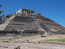
Both controlled the important commercial routes of the area which linked the Gulf Coast and the central highlands of Mexico, principally, but there is evidence of trade through here from even farther away.