Cerro Azul (Chile volcano)
In 1932, one of the largest explosive eruptions of the 20th century occurred at Quizapu Crater and sent 9.5 cubic kilometers (2.3 cu mi) of ash into the atmosphere.
The South Volcanic Zone has a long history of eruptions and poses a threat to the surrounding region.
Despite its inactivity, Cerro Azul could again produce a major eruption; if this were to happen, relief efforts would probably be quickly organized.
Volcanoes in Chile occur in the Central (CVZ), South (SVZ), and Austral Volcanic Zones (AVZ).
[3][4] This buoyant region prevents the slab (subducting tectonic plate) from diving deep into the mantle,[3] where the heat and pressure would destabilize the mineral chlorite, releasing water that would in turn cause melting and volcanism.
[4] Nearly 100 Quaternary (Pleistocene- or Holocene-age) independent volcanoes exist in the country, in addition to 60 volcanic complexes and caldera systems.
This range includes at least nine caldera complexes, more than 70 of Chile's stratovolcanoes and volcanic fields that have been active in the Quaternary, and hundreds of minor eruptive centres.
Its largest historical eruption was at Quizapu Crater, located on the north side of Cerro Azul's summit (see below), and its most active volcanoes are Llaima and Villarrica.
[9] Cerro Azul, just 7 kilometers (4.3 mi) south of Descabezado Grande volcano, is part of the Descabezado Grande–Cerro Azul eruptive system,[1] a volcanic field that comprises its two large namesake volcanic edifices and several smaller vents,[10] including 12 Holocene calderas.
[11] Both volcanoes lie on top of the Casitas Shield, a plateau built of over 100 lava flows that erupted in at least 12 volcanic episodes during the Quaternary period.
[10][11] As with the majority of the Andean volcanoes, Cerro Azul is a stratovolcano, meaning that it consists of layers, or strata, of volcanic ash and lava flows.
[12] The cone of Cerro Azul has a total volume of about 11 cubic kilometers (3 cu mi), and is a young feature, formed in the Holocene.
[11] Pleistocene glacial activity is evident in the form of 500 meter (1,640 ft) deep struts in the volcanoes' sides.
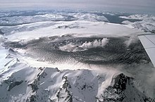
[14] The Quizapu Crater is almost perfectly circular, and rises to a prominence of 150 to 250 meters (490 to 820 ft) above the surrounding portions of the volcano.
[15] Cerro Azul is situated in a Mediterranean climate zone, characterized by hot and dry summers but mild and wet winters.
The number of plant species is likely to exceed 2,000, although no comprehensive study of the flora of Central Chile has been undertaken.
One, who was camped in a valley approximately 7 kilometers (4 mi) east of Quizapu, heard "a great noise and a cloud of ash" emanate from the mountain in the late afternoon.
[11] That night, two herdsmen near the site heard a continuous roar, punctuated by loud bangs and crackling sounds "like that of great rockslides".
None of the reports mention earthquakes or ash fall, though the crackling and banging sounds could be from block lavas (ʻaʻā).
Fascinated by the volcano, Ignacy Domeyko traveled to Chile to study the field and found its width to be 8–9 square kilometers (3.1–3.5 sq mi).
During this period, Cerro Azul sometimes erupted daily, sending columns of ash as far as 6 or 7 kilometers (about 4 mi) into the air.
[19] On April 10, Cerro Azul finally erupted, releasing a towering column or plume of white gas.
The ash was carried by wind into Puesto El Tristan in Argentina, about 47 kilometers (29 mi) away, where beginning at 1 PM it rained down for hours.
[13] Soon after, both the Tinguiririca and Descabezado Grande volcanoes began erupting, sending clouds of ash 800 kilometers (500 mi) into Argentina.
[22] Cerro Azul is in the South Volcanic Zone, where many volcanoes pose a threat to human life.
[23] Every known type of eruption (Hawaiian, Strombolian, Plinian, subplinian, phreatic, phreatomagmatic, and Vulcanian) has occurred at some point in the range.
[25] Despite the extent of its eruptions, the threat to humans from Quizapu is relatively small because of the remote location of Cerro Azul.