Ragged Mountain (Connecticut)
Occupying an area roughly 2.5 by 1.75 miles (4.02 by 2.82 km), Ragged Mountain rises steeply 500 feet (150 m) above the Quinnipiac River valley to the west.
The mountain formed near the end of the Triassic Period with the rifting apart of the North American continent from Africa and Eurasia.
Subsequent faulting and earthquake activity tilted the strata, creating the cliffs and ridgeline of Ragged Mountain.
Hot, dry upper slopes, cool, moist ravines, and mineral-rich ledges of basalt talus produce a combination of microclimate ecosystems on the mountain that support plant and animal species uncommon in greater Connecticut.
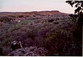
The mountain offers expansive views of the surrounding landscape from open summits and high cliff faces.
Wassel Reservoir has two dams, one on the NE and one on the S. It engulfs the small ridge called Shuttle Meadow Mtn, formerly traversed by the Blue Trail, on three sides.
At the northern end the reservoir is fronted by a series of sheer cliffs on both sides where it fills a deep rift valley.
Shuttle Meadow and Wassel Reservoirs are managed by the New Britain Water Department; the Metacomet Trail passes along their shores.
Several attempts to implement the TWRS and conserve Ragged Mountain and the neighboring traprock peaks were repulsed by local pro-development political forces in Southington and New Britain, in particular.