Raglan, New Zealand
Raglan (Māori: Whāingaroa[4] or Rakarana)[5] is a small beachside town located 48 km (30 mi) west of Hamilton, New Zealand on State Highway 23.
[13] Another says it was among the places the early Te Arawa explorer, Kahumatamomoe, with his nephew Īhenga, visited on their expedition from Maketū.
[14] The first Europeans to settle in the area, the Rev James and Mary Wallis, Wesleyan missionaries, were embraced and welcomed by local Māori in 1835.
[17] The Raglan economy initially featured flax and timber exports, followed by farming which remains the mainstay of the area.
[27] However, like other small ports, the main problem was the introduction of the inter-island roll-on roll-off ferries in 1962, with 40 Watersiders Union members made redundant in 1972, though cement volumes increased to a peak of 41,351 tons in 1974.
In 1941,[39] during World War II (1939–1945), the New Zealand Government took local ancestral land from indigenous Māori owners to construct a military airfield.
[44] On August 21, 2022, local councillors unanimously voted to begin the process of returning the airfield land to its original Māori owners.
[56] That accords with Ferdinand von Hochstetter's account of his 1859 tour, when he said that the Māori population was estimated at 400 and said that he had been told there were 122 Europeans, including 20 farmer-families.
Hochstetter said there were six or eight houses, with a tavern and a store in Raglan and a Māori village and an old pā at Horea on the north shore.
[86] That coincides with a decline in the Māori proportion of the population[87] – By 2018 there were 6 fewer unoccupied private dwellings at 471, but those occupied had increased to 1,275.
[94] In 2018, it produced a local history book about prominent Waikato chief Ngaere and how Ngāruawāhia and the Hakarimata Ranges were named in the late 1600s.
[95] In October 2020, the Government committed $414,300 from the Provincial Growth Fund to upgrade Mai Uenuku ki te Whenua Marae, creating 8 jobs.
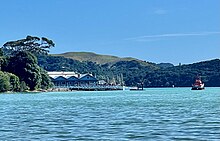
[100] It runs 12 km inland from the entrance, for the most part is less than 2 km wide, has a high-tide area of 32.96 km2 (12.73 sq mi), a low-tide area of 9.01 km2 (3.48 sq mi),[101] 2–4 m tidal range, with a spring-tide range of 2.8 m and neap 1.8 m, spring tide flow around 46 x 106 m3 and neap 29 x 106 m3.
is attributed to the formation of now relict intertidal shore platforms up to 700-m wide and ≤10 m below present-day mean high water level.
Today, the harbour has largely infilled with catchment sediment up to ~8-m thick, with 70% of its high tide surface area being intertidal."
The area is also home to the popular tourist destination, Bridal Veil Falls, which is located 20 kilometres southeast of the township and the unusual Lake Disappear 4 km further on.
[105] Raglan West developed after the farm containing the site of the Wesleyan Nihinihi mission station (see History above) was surveyed between 1940 and 1952.
[107] A concrete bridge from Raglan West replaced a tidal causeway in 2019 and work started on developing 259 residential lots.
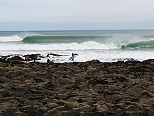
Vortex Bay is a soft peak east of the boat ramp that sometimes breaks on low tide when the swell is too large for the main three points.
[117] There is a regular market on the second Sunday of every month at the Raglan Old School Arts Centre in Stewart Street.
The main venue in Raglan for live music is the Yot Club, a regular stop for NZ musicians on national tours.
There is also live music at the Orca Restaurant and Bar, the Harbour View Hotel, the Raglan Club and The Old School.
Here there is a wide sandy beach with a background of bush-covered cliffs, and the picturesque Mount Karioi close at hand" and went on, "Many suitable landing places are to be found where parties may leave the launch for a ramble ashore or may picnic ‘neath the shade of the kowhai trees".
[123] (see also Walking trip resources below) Several sections of a Town2Surf cycle lane have been built, which will link the town with Ngarunui Beach,[124] and Te Ara Kākāriki Ocean Trails opened on 3 December 2016,[125] providing about 4 km (2.5 mi) of mountain bike trails in a pine forest on Wainui Reserve.
[143] (see also Environmental organisations below) Recycling in Raglan is managed by a non-profit organization called Xtreme Zero Waste.
The organization was founded in 2000, after Raglan's landfill closed and the town decided to find an alternative to transporting its waste elsewhere.
bore behind the Harbour View Hotel had 1,920 imp gal (8.7 m3)/day rising to about 8 ft (2.4 m) below the surface, though rather hard and tinged with iron.
bore for the dairy factory, 70 ft. above sea-level in Rose St, was polluted with ammoniacal nitrogen and chlorides too were high.
[157] In 1938, ratepayers petitioned the council for a water supply[53] and in 1938 DSIR reported on Waipatukahu Spring where, "Beautifully clear water rises in a pool perhaps 6 ft. across on the floor of Omahina Creek at a point some 10 ch (200 m) up from the south end of the tidal flat and a few chains above sea-level" and flow had been measured at 900,000 imp gal (4,100 m3)/day,[149] close to the 4,800 mentioned above.
Ultra violet treatment was added in 2008 and aquamats (high surface–area polymer filters) and other upgrades in 2017,[163] but the resource consent conditions for total suspended solids and faecal coliforms are still being breached.