Raheny
Raheny (Irish: Ráth Eanaigh) is a northern suburb of Dublin, Ireland, halfway from the city centre to Howth.
The coastal hamlet grew rapidly in the 20th century and is now a mid-density, chiefly residential, Northside suburb with a village core.
It is home to a range of retail and banking outlets, multiple sports groups including two golf courses, several schools and churches, Dublin's second-busiest library and a Garda station.
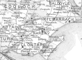
Nearby areas include Killester, Clontarf, Artane, Kilbarrack, Coolock and Donaghmede, and the skyline is dominated by Howth Head.
[12] The old church and graveyard complex behind the village plaza may reflect a remnant of the rath, as does some embankment behind the Scout Den.
[12] The ruined St. Assam's Church, dating from a 1712 reconstruction of a 1609 building, is believed to be the successor to early religious settlement.
[14] The site of this well is still visible under a stone cupola by the boating lake in the park, but it has been dry for several decades, despite efforts by municipal authorities to restart it.
The second well, dedicated to the patron saint of the area, St. Assam, lay in the field which now holds the Church of Our Lady Mother of Divine Grace.
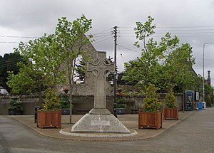
[13] The "Celtic-style" cross on display in the village (now on the main plaza but previously placed in other locations, including at the junctions of Main Street and Watermill Lane, and of Watermill Land and Howth Road) is a memorial to Marie Elizabeth Hayes, an early female medical graduate and 19th-century medical missionary from the area to India, paid for by locals in the area in which the doctor worked.
One of the latter, mapped as "Old Windmill", was situated on the Howth Road, on the slope above the Naniken River, and the other, "The Mill of Raheny", on Belmont hill, where the Capuchin friary now stands.
The Naniken, now culverted for more than half its length, flows from central Santry through Artane, then passes under the railway line in a syphon.
According to a chronicle of the ceremony of "Riding the Franchises", the Fox Stream used to mark the northern boundary of Dublin City.
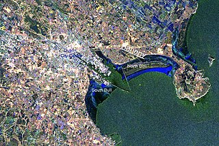
[24][25] A major feature is the nearly five-kilometre (3.1 mi) beach known as Dollymount Strand, on the nature reserve of North Bull Island, which is shared with Clontarf.
The Federation organised a range of activities, some in conjunction with the Raheny Business Association and some with the local authority and other official bodies, including strategic plans for the village, Neighbourhood Watch arrangements, community awareness weeks, the charitable Mayor of Raheny campaigns, events for older people, the setting up of the Millennium Clock in the middle of the village, and the moving of the Marie Elizabeth Hayes Cross.
In 2006, the Raheny Business Association began to sponsor a part-time paid coordinator to help the group in its work.
The following year, 2009, Raheny won the Best Urban Village award and was one of four areas of Dublin City to receive a commendation in the overall Tidy Towns competition.
[29] The Tidy Village group also runs community events such a Tallest Sunflower Competition [42] and beach cleans.
Adjacent to the library is the site of the first Catholic School in the village, built by William Sweetman circa 1820, now a solicitor's office.
The district also holds St. Francis Hospice and St. Joseph's Hospital (administered by Beaumont Hospital Board), as well as a small local health centre, a Credit Union branch (the local credit union merged with those of Artane and Coolock), a Garda Síochána station, located opposite the national school complex on All Saints' Drive, and one of Dublin's three driving test centres, at the St. Anne's shopping plaza.
The area's swimming pool, separate from but adjacent to St. Paul's College, closed to the public in 2006 after about 30 years of private operation,[45] and was later replaced by an apartment block development.
[46] The main local shopping facility is located in the centre of the village, on Howth Road beside the Santry River.
The building, completed in 1962, was designed by Peppard and Duffy architects, at the behest of Monsignor William Fitzpatrick and Archbishop John Charles McQuaid, with a capacity of 1500 to accommodate a burgeoning local congregation.
Regular worship ceased there when Our Lady's opened, and it was lightly used for the succeeding three decades, hosting St Joseph's Youth Club (Bru Sheosamh), Taize prayer services, and some meetings and occasional Masses.
[57] The district has a boys' secondary school, St. Paul's College, Raheny (attended by approximately 600 pupils in 2006) and one of Ireland's largest girls' secondary schools, Manor House,[52] as well as Ardscoil La Salle, on Raheny Road, a smaller mixed second level facility.
The splitting of the district, which also gives electoral stations on either side of the village centre (generally at the library and at the National Schools complex), was a source of local anger for many years.
Past figures include the late ex-Taoiseach Charles Haughey, and Councillor Niamh Cosgrave, of Foxfield, the latter in a rare move having been removed from the City Council for non-attendance.
The civil parish is still maintained in law, and its boundaries were last reviewed in 1985, with their extension to a greater part of Dublin Bay; it includes half, or slightly more, of Bull Island.
[26] The first major housing development in Raheny was St Anne's, built for Dublin Corporation on parts of the former Guinness estate not retained as a public park, which was followed by Cill Éanna and Ennafort, then Avondale, Rathmore Park, St Assam's and Foxfield, and Maywood were developed by the building firm of Curtis & Farrelly in the early to mid-1960s.
[2] There are a number of housing units for older people, notably in St. Anne's and at Avondale, and three retirement/nursing homes, one formerly dedicated for retired members of the Garda Siochana and their families, one run by the Little Sisters of the Poor at Sybil Hill, and one HSE facility.
[27] All of one and part of another of Raheny's townlands were largely developed by Dublin Corporation to form a new neighbourhood, Edenmore, in one of its largest-ever housing projects.