Rail trail
As shared-use paths, rail trails are primarily for non-motorized traffic including pedestrians, bicycles, horseback riders, skaters, and cross-country skiers, although snowmobiles and ATVs may be allowed.
The characteristics of abandoned railways—gentle grades, well-engineered rights of way and structures (bridges and tunnels), and passage through historical areas—lend themselves to rail trails and account for their popularity.
[1] The rail bed spans the length of the island, and connected Hamilton to St. George's and several villages, though several bridges are derelict, causing the trail to be fragmented.
The rail corridor stretches from Channel-Port aux Basques in the west to St. John's in the east with branches to Stephenville, Lewisporte, Bonavista, Placentia and Carbonear.
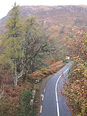
The majority of the rail trail passes through sparsely populated areas of the Canadian Shield, with historic trestle bridges crossing several rivers.
The trail is multi-use and depending on the section may allow hikers, bicyclists, horseback riders, cross country skiers and snowmobilers.
In North America, the decades-long consolidation of the rail industry led to the closure of a number of uneconomical branch lines and redundant mainlines.
The conversion of rails to trails hastened with the federal government passing legislation promoting the use of railbanking for abandoned railroad corridors in 1983 which was upheld by the U.S. Supreme Court in 1990.
As both the supply of potential trails increased and awareness of the possibilities rose, state governments, municipalities, conservation authorities, and private organizations bought the rail corridors to create, expand or link green spaces.
The Atlanta BeltLine is a sustainable redevelopment project that will provide a network of public parks, multi-use trails and transit along a historic 22-mile railroad corridor circling downtown and connecting many neighborhoods directly to each other.
Up to date, the 23 km long Nordbahntrasse in Wuppertal is still the rail trail with the highest standard in Germany and is a prime example of conversion of an abandoned railway track into a multiuser cycling path.
[10] The development of rail trails in the United Kingdom grew after a major programme of railway line closures in the 1960s known as the Beeching cuts.
Other urban and suburban rail trails include the Fallowfield Loop Line in Manchester, the Middlewood Way in Cheshire and the Ebury Way in Watford.
[13] With more than 2,500 kilometers of rail trails (Via Verde)[14] in a network of 117 cycling and walking itineraries, Spain ranks high in the European greenways scene.
Many of the converted tracks were originally built for the mining industry, connecting remote mountain sites with port locations on the coast, now offering picturesque rides from wild interior landscapes to the seaside, following near-flat routes with long-spanning viaducts and bridges, plus a number of tunnels.
While many lines were ripped up and the sections of the land acquired by private owners, a number of former railways do exist intact, thus providing the option for the development of many rail trails in the future.
[19] The RAVeL network in Belgium combines converted tracks, byways and towpaths, adding up to a total of 1,200 km (750 mi) , a significant figure considering the size of the country.
Dozens of rail lines sprang up, aided by the overly enthusiastic "Octopus Act", but soon became unprofitable as the gold ran out, leading to a decreased demand for timber in turn.
[31] Inspired by the 3-mile-long (4.8 km) Promenade plantée (tree-lined walkway), a similar project in Paris completed in 1993, the High Line has been redesigned and planted as an aerial greenway and rails-to-trails park.
Even residents who are not encroaching on railway lands may oppose conversion on the grounds of increased traffic in the area and the possibility of a decline in personal security.
In the United States, the Surface Transportation Board (STB) regulates railroads, and can allow a corridor to be "Rail Banked" or placed on hold for possible conversion back to active status when or if future need demands.
The Connecticut Department of Energy and Environmental Protection acquired the line from Penn Central in 1969, and subsequently signed a long-term lease with the railroad.
Their primary revenue is tourist operations, so rail traffic is seasonal; though all three have been granted rights to carry freight, should customers show interest.
One example occurred in 2012 in Clarence, Pennsylvania, where the R.J. Corman Railroad Company received permission to rebuild 20 miles (32 km) of railbanked line to serve new industries.
[38] Conrail had ceased operating over the line in 1990, and 10 miles (16 km) was converted to the Snow Shoe Rails to Trails.
Therefore, the rail trails that succeeded them are often fairly straight and ideally suited to overcome steep or awkward terrain such as hills, escarpments, rivers, swamps, etc.
Rail trails often share space with linear utilities such as pipelines, electrical transmission wires, and telephone lines.
[40] The initial 705 miles (1,135 km) stretch of the Illinois Central Railroad is the most liberal in the world with a width of 200 feet (61 m) along the whole length of the line.