Rangitoto Island
Tama-te-kapua was the captain of the Arawa waka (canoe) and was badly wounded on the island, after having lost a battle with the Tainui iwi (tribe) at Islington Bay.
The first part of the eruption sequence, dated by radiocarbon methods at about 628 years ago (= 553 ± 7 yrs BP)[11] was initially wet and produced surges of volcanic ash that mantled neighbouring Motutapu Island from alkaline olivine basalt eruptives sourced from the north cone area.
This was based on recognition of a number of horizons of tiny volcanic glass shards, seemingly erupted from Rangitoto, in sediment cores from Lake Pupuke.
The University scientists did, however, core a thin basalt lava flow within marine sediment dated at 6000 years old, and hypothesised that this was an even earlier eruption from Rangitoto.
[13][14] Civil Defence officials said the discovery did not make living in Auckland any more dangerous, but did change their view of how an eruption might proceed.
[16][17] In 2018 many of the original group of Auckland University geologists reported on their latest research and reinterpretation of the evidence and concluded that Rangitoto only erupted once, about 600 yrs ago, possibly in two phases.
[4] The external form of Rangitoto consists of a circular, gently sloping shield composed of numerous overlapping lava flows.
[4] Withdrawal of magma back down the throat of the volcano at the end of the eruptions has resulted in slight subsidence of the scoria cones.
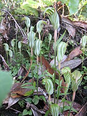
[9] The vegetation pattern was influenced by the more recent eruptions creating lava flow crevices where pōhutukawa trees (Metrosideros ssp.)
[22] The island is considered especially significant because all stages from raw lava fields to scrub establishment and sparse forests are visible.
As lava fields contain no soil of the typical kind, windblown matter and slow breaking-down processes of the native flora are still in the process of transforming the island into a more habitable area for most plants (an example of primary succession), which is one of the reasons why the local forests are relatively young and do not yet support a large bird population.
[26] As the area is a DOC-administered reserve (in partnership with the tangata whenua Ngāi Tai and Ngāti Paoa),[8] visitors may not take dogs or other animals onto the islands.
[9] The island was purchased for £15 by the Crown in 1854, very early in New Zealand's colonisation by Europeans, and for many years served as a source of basalt for the local construction industry.
Military installations were built during World War II to support the Auckland harbour defences and to house U.S. troops or store mines.
Other ships include Ngapuhi (1900 - her stern remained in 2014), Jubilee (1857), Arapawa (1908), Rothesay Bay (1877), Gladbrook (ex Countess of Anglesea 1877), Elinor Vernon (1876), Polly (ex Skovland 1891), Columbia (1899 - part of the keel and frame remained in 2014), Dartford (1877) and Rarawa (1903 - the bow, framing, iron plating and stern with two propeller shaft housings were visible above the low water mark in 2014).
However, 30 of the 140 baches remain as of 2010[update],[32] and some are being preserved to show how the island used to be, once boasting a permanent community of several hundred people, including many children.
The buildings included some more permanent structures like a seawater pool built of quarried stones by convict labour, located close to the current ferry quay.
[45] Regular ferry services and island tours by tractor-trailer are provided by Fullers from Auckland city centre.
[47] An alternative to walking, a land train, coordinated with the ferry sailings, takes visitors to a short way below the summit.