Rannerdale Knotts
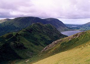
Rising from the Buttermere valley, it is one of the smaller Cumbrian hills and is overlooked by a number of surrounding fells, such as Grasmoor, Whiteless Pike and, across Crummock Water, Mellbreak and the High Stile ridge.
The North Western Fells occupy the area between the rivers Derwent and Cocker, a broadly oval swathe of hilly country, elongated on a north-south axis.
A tumbling descent of crag and scree then follows as the end of the ridge drops steeply to the valley floor, halfway along the shore of Crummock Water.
Low Bank lies across the Causey Pike Fault and is part of the Buttermere Formation, an olistostrome of disrupted sheared and folded mudstone, siltstone and sandstone.
[3] Rannerdale Knotts is often ascended from Buttermere, making use of the good path going up Whiteless Pike, before turning west north-west along Low Bank at the col at 950 ft (290 m).
There is a more direct ascent up the west face of the fell from Hause Point at Rannerdale, accessed from the B5289 road on the eastern shore of Crummock Water.
Cumbria was ostensibly part of Scotland, until seized by the forces of William Rufus in 1092, following a dispute with Scottish king Malcolm III, himself killed a year later at the Battle of Alnwick.
Around 1120, Henry I of England gave the Barony of Copeland to Ranulph's brother William les Meschines, who settled at Egremont on Cumbria's western coast, then initiated the construction of the castle there.
The local warriors were commanded by the Earl Boethar, who succeeded in drawing the Normans into the side valley of Rannerdale, then routed them with a surprise attack from above and behind.
The battle is imagined to have taken place in the side valley of Rannerdale, which runs east of the summit of the fell, west of Whiteless Pike and south of Grasmoor.