Rappahannock County, Virginia
The name "Rappahannock" comes from the Algonquian word lappihanne (also noted as toppehannock), meaning "river of quick, rising water" or "where the tide ebbs and flows.
In 1728, the land that became Rappahannock County began to be granted to individuals by agents of King George II of Great Britain.
After the American Revolution, the remaining land, located primarily in the mountains, was granted by the Commonwealth of Virginia.
[5] The county was primarily agricultural and self-sufficient, with a few merchants and craftsmen providing goods that could not be made on the farms.
Instead, farmers in the county grew wheat, oats, corn, and hay and maintained herds of cattle, sheep, and swine.
The county was well-watered by streams and rivers originating in the Blue Ridge Mountains, and mills along these waterways were built to grind corn and grain, saw lumber, and card and weave wool.
Rappahannock County moved into the 20th century with the introduction of telephones, electricity, automobiles, improved roads, high school education, and a local newspaper.
About 32,000 acres of Rappahannock County land was conveyed to the federal government for the Park, displacing multiple families.
Construction of Skyline Drive in Shenandoah National Park began in 1931 through the Civilian Conservation Corps (CCC), and several of their camps were established at Beech Spring on Route 211 west of Sperryville and north and south of Thornton's Gap at the top of the Blue Ridge.
These provided work for local men and a market for farmers for produce, meat, milk, and eggs to feed the corpsmen.
In the 1970s, there was an influx of young adults into the county who were seeking a rural lifestyle and who brought with them their skills and talents as artists, artisans, musicians, carpenters, and other craftsmen.
Rappahannock County continues to cater to tourists and locals alike, with chic restaurants, bars, artisan shops, artist studios, bed and breakfast accommodations, and antique stores.
However, the county remains primarily rural, agricultural, and undeveloped, in large part due to tight governmental control of land zoning and restrictions on subdivision.
These are located in Ben Venue, Flint Hill, Laurel Mills, Sperryville, and the town of Washington.
The remaining 219 miles are secondary roads which provide a link to the rural residential and farm areas of the county.
This was primarily due to freed slaves moving north and fewer people needed to operate farms.
“All seem to appreciate the beauty and quiet of the county, its family farms, the quality of its rivers and streams, and the unblemished views of the night skies.”[23] Rappahannock County contains a land area of 266.6 square miles; of this 73.7% is forests (including 49.5 square miles in Shenandoah National Park), 20.1% is pasture/farmland, and the remainder is roads and buildings and their surroundings.
The 25-acre zoning restriction for land parcels outside the villages has clearly become a defining feature of Rappahannock, one that distinguishes it as a rural oasis in a region of hyper-development.
We take credit for comprehensive planning happening here before it was required.”[29] Historically, the county has had a rural economy based on agriculture.
Some farmers don't own the land they farm but lease it from owners who are content to have pastures maintained and fences kept in good order.
[30] Orchard land in the county was devoted to apple production for many years, with a smaller peach crop.
Wineries, organic farms, and consumer demand for grass-fed beef have created new opportunities for farmers.
In a survey by the University of Virginia for the Foothills Forum, residents wanted the beauty, the mountain vistas, the clean rivers and the dark, starlit skies preserved, even if they must drive out of the county to shop at a supermarket or fill a prescription.
In fiscal year July 2020-June 2021, the county government budget was $26.6 million, of which 50% was designated for education of students in the two public schools.
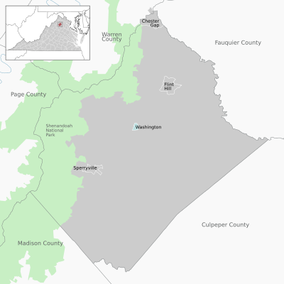
There is one incorporated town (Washington) and five village settlements in the county (Chester Gap, Flint Hill, Amissville, Sperryville, and Woodville).
[46] In nighttime photos taken from space, the county is one of the few conspicuous dark spots amid a blaze of lights illuminating the East Coast from Miami to Maine.
Amissville, Castleton, Chester Gap, Flint Hill, and Washington handle both fire and ambulance calls; Sperryville has separate squads.
The annual Rappahannock County Arts Tour provides an opportunity to visit artists in their studios.
Other amusements and events include a 9-hole golf course; the annual Fodderstack 10K race; Sperryfest street fair featuring the Great Rubber Duck Race Down the Thornton River; Oktoberfest held in Sperryville, a collaborative effort by local farms, breweries, and businesses involving beer and food prepared and served by the brewers and farmers of the county; the annual Rappahannock Farm Tour; the annual Artists of Rappahannock tour of artists’ studios; Old Dominion Hounds Point-to-Point races; the Amissville carnival and parade; Rappahannock Rough Ride for bicyclists; John Jackson Piedmont Blues festival; Fourth of July celebration and fireworks; and Christmas in Little Washington parade and festivities.
Recreation in Rappahannock County includes fishing, horseback riding, camping, hiking, and canoeing, particularly in Shenandoah National Park.