Rawalpindi
Rawalpindi is situated adjacent to Pakistan's capital Islamabad, and the two are jointly known as "twin cities" because of the social and economic links between them.
[13][14] In 1951, the Rawalpindi conspiracy took place in which leftist army officers conspired to depose the first elected-Prime Minister of Pakistan, Liaquat Ali Khan.
[20] The city is also home to historic havelis and temples, and serves as a hub for tourists visiting Rohtas Fort, Azad Kashmir, Taxila and Gilgit-Baltistan.
[28] Another theory suggests that the city was named after Bappa Rawal for his role in leading a strong resistance against invasions; however, there is no credible historical evidence to support this claim.
In the region north-west of Rawalpindi, traces have been found of at least 55 stupas, 28 Buddhist monasteries, 9 temples, and various artifacts in the Kharoshthi script.
[34] Situated along an invasion route, the settlement did not prosper and remained deserted until 1493, when Jhanda Khan Gakhar re-established the ruined town, and named it Rawal.
[36] Gakhars fortified a nearby caravanserai, in the 16th century, transforming it into the Rawat Fort in order to defend the Pothohar plateau from Sher Shah Suri's forces.
[37] Construction of the Attock Fort in 1581 after Akbar led a campaign against his brother Mirza Muhammad Hakim, further securing Rawalpindi's environs.
[39] Emperor Jehangir visited the royal camp in Rawalpindi in 1622, where he first learned of Shah Abbas I of Persia's plan to invade Kandahar.
[39] The city's administration was handed to Sardar Milkha Singh, who then invited traders from the neighbouring commercial centers of Jhelum and Shahpur to settle in the territory in 1766.
[39] The Sikh rulers allied themselves with some of the local Gakhar tribes, and jointly defeated Syed Ahmad Barelvi at Akora Khattak in 1827, and again in 1831 in Balakot.
[39] Jews first arrived in Rawalpindi's Babu Mohallah neighbourhood from Mashhad, Persia in 1839,[42] in order to flee from anti-Jewish laws instituted by the Qajar dynasty.
[44] The city's Garrison Church was built shortly after in 1854,[38] and is the site where Robert Milman, Bishop of Calcutta, was buried following his death in Rawalpindi in 1876.
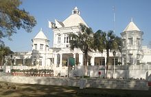
[38] A large market was opened in central Rawalpindi in 1883 by Sardar Sujan Singh, while the British further developed a shopping district for the city's elite known as Saddar with an archway built to commemorate Brigadier General Massey.
Scientists from Porton Down carried out poison gas tests on British Indian Army soldiers during the Rawalpindi experiments over the course of more than a decade beginning in the 1930s.
Having been the largest British Cantonment in the region at the dawn of Pakistan's independence, Rawalpindi was chosen as headquarters for the Pakistani Army, despite the fact that Karachi had been selected as the first capital.
[15] In 1951, the Rawalpindi conspiracy took place in which leftist army officers conspired to depose the first elected Prime Minister of Pakistan, Liaquat Ali Khan.
As a result, Rawalpindi saw most major central government offices and institutions relocate to nearby territory, and its population rapidly expand.
[50][51] The military dictatorship of General Zia ul Haq hanged Pakistan's deposed Prime Minister, Zulfikar Ali Bhutto, in Rawalpindi in 1979.
[52] In 1980, tens of thousands of Shia protestors led by Mufti Jaffar Hussain marched to Rawalpindi to protest a provision of Zia ul Haqs Islamization programme.
[49] A spate of bombings in September 1987 took place in the city killing 5 people, in attacks that are believed to have been orchestrated by agents of Afghanistan's communist government.
Rawalpindi features a humid subtropical climate (Köppen: Cwa)[59] with hot and wet summers, a cooler and drier winter.
[62] Each Mohallah has narrow gallies (streets), and the grouping of houses around short lanes and cul-de-sacs lends a sense of privacy and security to residents of each neighbourhood.
British colonialists also built the Saddar Bazaar south of the historic core, which served as a retail center geared towards Europeans in the city.
[68] Many of the old city's neighbourhoods continue to bear Hindu and Sikh names, such as Krishanpura, Aria Mohallah, Akaal Garh, Mohanpura, Amarpura, Kartarpura, Bagh Sardaraan, Angatpura.
Rawalpindi was a majority Hindu and Sikh city prior to the Partition of India in 1947,[68] combined composing 51.05 percent of the total population according to the 1941 census.
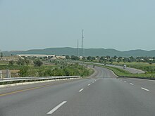
The Karakoram Highway provides access between Islamabad and western China, and an alternate route to Central Asia via Kashgar in the Chinese region of Xinjiang.
It houses a state-of-the-art cinema, Cinepax,[92] a Metro Cash and Carry supermart, an outlet of McDonald's, gaming lounges, Motion Rides and other recreational facilities.
[93][94] Rawalpindi is situated near the Ayub National Park formerly known as 'Topi Rakh' (keep the hat on) is by the old Presidency, between the Murree Brewery Co. and Grand Trunk Road.
[97] 97.4% of children ages 6–16 in urban areas of Rawalpindi District are enrolled in school – the third highest percentage in Pakistan after Islamabad and Karachi.