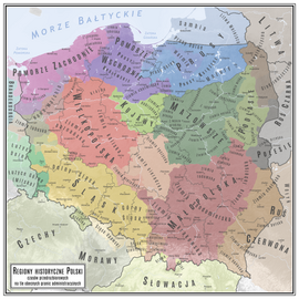
Red Ruthenia
Centred on Przemyśl and Belz, it has included major cities such as: Chełm, Zamość, Rzeszów, Krosno and Sanok (now all in Poland), as well as Lviv and Ternopil (now in Ukraine).
[3] The first known inhabitants of northern Red Ruthenia were Lendians[4] and White Croats,[5] while subgroups of Rusyns, such as Boykos and Lemkos, lived in the south.
[6] According to Marcin Bielski, although Bolesław I Chrobry settled Germans in the region to defend the borders against Hungary and Kievan Rus' the settlers became farmers.
Casimir the Great settled German citizens on the borders of Lesser Poland and Red Ruthenia to join the acquired territory with the rest of his kingdom.
In determining the population of late medieval Poland, colonisation and Polish migration to Red Ruthenia, Spiš and Podlachia[7] (whom the Ukrainians called Mazury—poor peasant migrants, chiefly from Mazowsze[8]) should be considered.
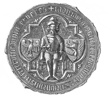
The only serious conflict during his time as governor involved his approach to the Eastern Orthodox Church, which angered the local Catholic boyars.
[citation needed] The Polish name Ruś Czerwona (translated as "Red Rus") came into use for the territory extending to the Dniester, centring on Przemyśl.
A number of castles were built at this time, and the cities of Stanisławów (Stanyslaviv in Ukrainian, now Ivano-Frankivsk) and Krystynopol (now Chervonohrad) were founded.