Redgrave and Lopham Fens
Redgrave and Lopham Fens is a 127 hectare biological Site of Special Scientific Interest between Thelnetham in Suffolk and Diss in Norfolk.
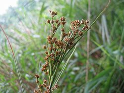
Dry marginal woodland becomes fen grassland, dominated by purple moor-grass, which grades into mixed fenland of reed and sedge beds.
Such work includes rush mowing, sedge harvesting, scrub clearance, coppicing and fence construction.
[18] The site has also introduced a successful grazing regime to reduce the cost incurred from mowing such a large area of fen.
This has visibly benefited the fen structure and means only the larger saw sedge beds are now on a manual cutting rotation.
The use of grazing has led to the emergence of a greater mosaic of vegetation and habitat types within the fen and has inhibited the expansion of scrub.
[11] Redgrave and Lopham Fens lies at the headwaters of the Waveney and Little Ouse rivers[23] and had for centuries provided natural resources for the local population.
The cutting of peat for fuel lead to the creation of open pools edged in reedbeds and the pathways between them became species-rich fen meadows.
This led to a change in the fen's hydrology in the early 1960s as it went from a year-round water supply to alternating summer drought and winter floods.
The loss of water and lack of management led to the degradation of the fen, and scrub began to invade large areas.
In 1961 the Suffolk Wildlife Trust gained control of the site but insufficient resources meant the large scale work they wished to carry out to return it to its previous state could not be achieved; the condition of the overall fen continued to decline.
At this time the Environment Agency undertook studies to determine the extent of damage to the fen and how restoration could best be carried out.
Eventually a site was located 3 km southeast of the reserve and planning and construction of the new borehole was carried out at a cost of £1.2 million.
By summer 2002 the maximum groundwater recharge level was believed to have been reached and the hydrological recovery closely followed modeling predictions.
These would allow direct control of water levels within the fen and protect the site from flooding or drought events.
Around 80 hectares of wood and scrub were identified for clearance, all of which has now been removed and has opened up land to be reclaimed by the fen habitat.
To restore the fen to its previous state the decision was made to strip off the peat down to a level where it was undamaged and allow natural growth from that point.