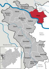
Rees, Germany
It is located on the right bank of the Rhine, approximately 20 km east of Kleve.
Rees is administratively organized in eight communities: The neighbouring municipalities are Oude IJsselstreek (province of Gelderland, NL) and Isselburg (district of Borken) in the North, Hamminkeln and Wesel in the East, Xanten in the South (all district of Wesel), and Kalkar and Emmerich in the West.
The name Rees most probably goes back to the Kleverlandish term "Rys", which means "willow grove".
On 14 July 1228 Rees was granted municipal rights by Heinrich I von Müllenark, Archbishop of Cologne.
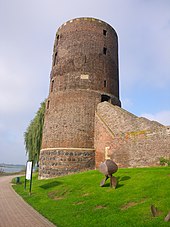
The city was almost completely destroyed by an Allied air raid on February 16, 1945 during World War II.
[4] The train station Empel-Rees, located about 4 km from the city center, is connected northbound to Emmerich and Arnhem and southbound to Wesel, Oberhausen, Duisburg, Düsseldorf, Cologne, Bonn, and Koblenz.
For pedestrians and bicyclists, transfer across the Rhine is provided by two ferries from Easter holidays through October.