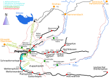
Reintal
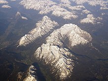
The upper Reintal, which was shaped by the glacier and today forms a U-shaped glacial valley, ends between the Hohe Gaifkopf in the west and the Schachen in the east.
In the upper Reintal the rubble from rockslides from the southern faces of the Hochwanner and Hinterreintalschrofen also play a rôle in the shaping of the valley.
On 23 August 2005 the former was completely filled with sediment as a result of heavy rain (200mm in 24h) whereupon high pressure broke the natural dam.
[1][2] A moderately steep climbing path to the Zugspitze runs through the Reintal, the section as far as the Knorr Hut forming part of the Red Trail of the Via Alpina.
Due to its great distance from any settlements and because no roads runs up the valley the Reintal is very unspoilt and still very natural, despite being easily accessible on foot.