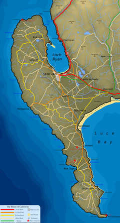
Rhins of Galloway
Other villages are dotted up and down the peninsula, including Kirkcolm, Leswalt, Lochans, and, in the South Rhins, Stoneykirk, Sandhead, Ardwell, and Drummore.
With around 50 miles (80 km) of coastline running from Stranraer in the north to Torrs Warren in the south, the sea heavily influences the land.
The Rhins are exposed to the westerlies from the Atlantic and thus receive a lot of rainfall (around 1,000 millimetres or 40 inches per year); this has led to the peninsula being principally used for farming, with the relatively flat land offering good dairy and beef production.
The natural geography of the Rhins has led directly to the use of the area for development[clarification needed]: the entire peninsula acts as a huge breakwater against the currents of the North Channel and, to a lesser extent, the Atlantic.
Here the land and rocky cliffs support a diverse range of animals and plants, with the Mull area designated a Site of Special Scientific Interest and also an RSPB nature reserve.
The land narrows significantly north of the Mull, south of Rhins, forming an isthmus dividing two bays (the East and West Tarbets).
In ancient times boats were brought ashore and moved across the isthmus [citation needed] by human resources, with the aid of log rollers and lubrication—all this effort aimed to avoid navigating around the Mull with its dangerous currents.
Their chieftains lived in hill-forts, like that of Dunman, "fort of gables", Kirkmaiden, 400 feet (120 metres) above sea level; some in drystone brochs, like Doon Castle at Ardwell Point.
The importance of the area's proximity to Ireland led to significant infrastructure being developed, most notably the link to the railway network, which was laid to Portpatrick to ensure a fast passage for the mail boat to Donaghadee.
The bombing range in Luce Bay was used extensively throughout the second world war, with facilities based at West Freugh and Drummore In modern times the peninsula consists of a patchwork of farms running the full length of the land.