Rio Grande Project
[3] Long before Texas was a state, the Pueblo Indians used the waters of the Rio Grande with simple irrigation systems that were noted by the Spanish in the 16th century while conducting expeditions from Mexico to North America.
The river would take out some of these primitive structures in its annual floods, and a large, coordinated project would be needed to construct permanent replacements.
[4] By the 1890s, water use in the upper basin was so great that the river's flow near El Paso, Texas, was reduced to a trickle in dry summers.
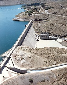
To resolve these problems, plans were drafted up for a large storage dam at Elephant Butte, about 120 miles (190 km) downstream of Albuquerque, New Mexico.
The first elements of the project to be built were the Leasburg Diversion Dam and about 6 miles (9.7 km) of supporting canal, begun in 1906 and finished in 1908.
In response, Reclamation began planning for the extensive 465-mile (748 km) drainage system of the Rio Grande Project in 1916.
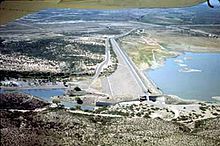
Caballo Dam, the second major storage facility of the project located 21 miles south of Truth or Consequences, New Mexico was built from 1936 to 1938.
With the benefit of flow regulation, a small hydroelectric plant was completed in 1940 at the base of Elephant Butte Dam.
Noted as historic are the diversion dams and the unlined irrigation canals; most of the mechanical fixtures in the system have been routinely replaced and are non-historic.
[7] The reservoir and dam receive water from a catchment of 28,900 square miles (75,000 km2), about 16% of the Rio Grande's total drainage area.
[7] The Elephant Butte hydroelectric station is a base load power plant that draws water from the reservoir and has a capacity of 27.95 megawatts.
[9] The dam has no power generation facilities, although it has been proposed that a small hydroelectric plant be installed at its base for local irrigation districts.
[11] The dam diverts water into the Rincon Valley Main Canal, which is 28.1 miles (45.2 km) long and has a capacity of 350 cu ft/s (9.9 m3/s).
[12] The dam diverts water into the 13.7-mile (22.0 km) Leasburg Canal, which irrigates 31,600 acres (12,800 ha) of land in the upper Mesilla Valley.
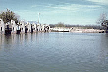
The Mesilla Diversion Dam is located about 40 miles (64 km) upstream of El Paso and consists of a gated overflow structure.
The Franklin Canal is 28.4 miles (45.7 km) long and takes water into the El Paso Valle, where it irrigates 17,000 acres (69 km2).
Elephant Butte Reservoir, with 36,897 acres (149.32 km2) of water at full pool, is popular for swimming, boating, and fishing.
In 1896, it was affirmed by the United States Geological Survey (USGS) that the river's flow was decreasing by 200,000 acre-feet (250,000,000 m3) annually.
[18] In 2001, the river failed to reach the Gulf of Mexico but instead ended 500 feet (150 m) from the shore behind a sandbar, "not with a roar but with a whimper in the sand".
Other than extensive diversions, exotic introduced, fast-growing and water-consuming plants, such as water hyacinth and hydrilla, are also leading to reduced flows.
The United States government has recently attempted to slow or stop the progress of these weeds by introducing insects and fish that feed on the invasive plants.