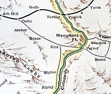
Ripley, California
The townsite was named to dedicate former Santa Fe Railway president Edward Payson Ripley.
[4] The town aimed to be a resort location until it was damaged by a flood that swept part of the valley in 1922.
According to the United States Census Bureau, the CDP covers an area of 1.7 square miles (4.4 km2), all of it land.
This area has a large amount of sunshine year round due to its stable descending air and high pressure.
The area is served by Palo Verde Irrigation District and formerly the Arizona and California Railroad.
The railroad's Blythe Division track ends just west of Ripley.
There were 295 housing units at an average density of 173.5 per square mile (67.0/km2), of which 78 (35.8%) were owner-occupied, and 140 (64.2%) were occupied by renters.