River Adur
The western Adur rises at Slinfold, from where it flows around Coolham and then through Shipley, where Hammer Pond and Lancing Brook join it on the right bank.
[3] On the left bank, it is joined by the outflow of Knepphill Pond, which forms part of the Knepp Castle pleasure grounds laid out by John Nash in 1806–13.
[4] At Bay Bridge it is crossed by the A24 road, is joined by another tributary on the left bank, and flows on to West Grinstead, passing through the remains of a lock.
The land was periodically flooded by incoming tides, and water trapped in pools was then evaporated to extract salt.
The industry operated from Anglo-Saxon times until the early 17th century, when it was unable to compete with sources of rock salt, mined in other parts of the country.
The river continues through a gap in the South Downs near Lancing College where the Adur is fed by the Ladywell Stream, and is then crossed by the A27 Shoreham By-pass.
It is 500 feet (150 m) long, with 27 spans, and although it was largely reconstructed in the early 20th century, it is still of great interest, because it is probably the only one of its type which still exists.
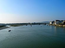
The mouth of the Adur is now two miles (3 km) from the town centre of Shoreham due to longshore drift.
Previously, the river mouth was further east, in Portslade, but an opening to the sea was made which allowed the creation of Southwick Ship Canal.
The river had previously been known as the Bramber, and was also recorded as the Sore in the sixteenth century, the latter probably a back-formation by William Harrison's Description of England (1577) from Shoreham (often Sorham in early sources).
[3] When Defoe visited in the 1720s, he noted that Shoreham was a seafaring town, with many of the inhabitants being ship's carpenters, chandlers or otherwise involved in trades connected with shipbuilding.
However, in 1816 a new channel was cut through the shingle, and the original course of the river became the Southwick Ship Canal as development work took place over the next forty years.
Seventy-nine trustees were appointed by the Act to carry out the work, assisted by the Commissioners of Sewers for the Rape of Bramber.
The canal ran from Bines Bridge to Baybridge at West Grinstead, and included two pound locks, each with a rise of 7 feet (2.1 m).
The Brighton Railway arrived in the area in 1861, when a branch from Shoreham to Horsham was constructed, which was in direct competition to the river.
The Adur trustees could no longer afford to repay their loans from 1865, while the Baybridge Canal was virtually unused from 1861, and officially closed on 1 September 1875.
Some traffic continued to use the Adur, and in 1905 a tug with barges conveyed 12,989 tons of material from Shoreham to a cement works at Beeding.