River Bann
[3] The river winds its way from the southeast corner of Ulster[4] to the northwest coast,[5] pausing in the middle to widen into Lough Neagh.
[7] According to C. Michael Hogan, the Bann River Valley is a settlement area for some of the first human arrivals in Ireland after the most recent glacial retreat.
[9] It is also seen as a religious, economic and political divide, with Catholics and Irish nationalists being in the majority to the west, and Ulster Protestants and unionists in the majority to the east; and with the financial and industrial capital of Greater Belfast to the east with the west of the Bann being more agricultural and rural.
At Whitecoat Point near Portadown, it is joined by the Cusher River and connects with the now disused Newry Canal, which once gave access south to the Irish Sea.
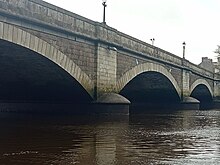
The bridge is the lowest on the navigable section, with an air draught of around 10 feet (3 m), although in strong northerly winds, water backs up in the river and the headroom is reduced.
Exploration of the town from the river is difficult, because water levels at Shillington Quay and at the jetty a little further upstream are very shallow.
The Lower Bann is 64 kilometres (40 mi) long[16] and is a canalised waterway, with five navigation locks, at Toome, Portna, Movanagher, Carnroe and Castleroe.
The river is very popular with water sports enthusiasts, anglers and cruisers and has minimal commercial traffic.
The water level on the Lower Bann is controlled by the Rivers Agency using gates situated at Portna (near Kilrea) and The Cutts at Coleraine.
Quays and swing bridges were erected, and various alterations had to be made around Lough Neagh to cope with the drop in the surface level.
Those to the south of the lake had to contribute towards the drainage and navigation works which had been completed, and also find £800 per year for ongoing maintenance, with no source of income to cover it.
Coleraine was expanded as a port, but even the Lower Bann did not generate the expected revenue, and the adjoining counties had to finance an annual deficit of around £400.
[29] Flooding around the southern shores of Lough Neagh continued to be a problem, and in 1882 the chairman of Portadown Town Commissioners suggested that Alexander Nimmo's scheme should be revived.
[30] Both the Monck Commission, which sat in the early 1880s, and an enquiry into the Board of Works held in 1887, suggested that for the benefit of flood relief, the navigation should be abandoned, and that the three Trusts were counter-productive.
No action was taken, and when the President of the Institution of Civil Engineers, Sir Alexander Binnie, was asked for his advice in 1906, he came to a similar conclusion.
Some improvements to weirs were made by the Ministry of Finance, and there was some traffic, consisting mostly of sand dredged from Lough Neagh and used by brickworks.
Finally, in 1954, responsibility for the Upper Bann was transferred to the Ministry of Commerce, the Trust was disbanded, and the navigation was abandoned.
[32] The Lower Bann has seen an increase in use by pleasure craft, and now supports four marinas, two at Coleraine, one at Drumaheglis and one at Portglenone.