River Brent
17.9 miles (28.8 km) in length, it rises in the Borough of Barnet and flows in a generally south-west direction before joining the Tideway stretch of the Thames at Brentford.
The oldest Pleistocene deposit, Pebble Gravel, is found across the upper, northern margin of the catchment area, from Bushey Heath to Chipping Barnet.
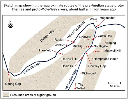
In the early twentieth century, it was suggested that the River Thames, after descending through Oxfordshire, entering the London Basin near the Goring Gap and running north-east from there, continued in that direction prior to the ice advance, past Watford and along the line of the Vale of St Albans.
[8] Although flint is the main component of this gravel, it has been known since the late nineteenth century that it also contains in places a notable quantity of chert derived from Lower Greensand Beds in the Weald.
He also suggested that similar gravel, located further north-east near Northaw at a slightly lower altitude, was also deposited by an ancestral Mole-Wey, but at a later date (which could have been around 1.75 million years ago).
[20] In the early twentieth century it was concluded that the Thames must have been diverted to its more southerly course of today by the ice advance up the Vale of St Albans to Watford.
[12] In the case of the overflow through the Carpenders Park gap (today followed by the West Coast Main (railway) Line between London Euston and Watford), the Thames overspill surged through Wealdstone and Kenton.
[28] As illustrated on a geological map of the area, it is striking that Dollis Brook, for the greater part of its length between Barnet Playing Fields and Henly's Corner, follows a north-south line close to the western limit of glacial till left by the ice sheet lobe which extended to Finchley.
[29] Similarly, Mutton Brook follows an east-west line which is close to the southern limit of glacial till left by the ice sheet lobe.
And it would have forced northward-flowing drainage coming down from Highgate and Hampstead to have turned to the west, alongside the southern edge of the ice lobe (thus forming Mutton Brook).
That stream probably cut back in a north-easterly direction along the line of the former proto-Mole-Wey valley bottom (the near-flat surface of which would by then have been covered by a certain amount of glaciofluvial material deposited by meltwater flowing from the front of the ice lobe).
That erosion mostly took place in periods of "high discharge, under cold climatic conditions" when river flow was augmented and when vegetation was thin.
[37] Younger ones include almost continual stretches of Taplow and Kempton Park deposits in the valley bottom and adjacent slopes downstream of Brent Reservoir.
During the long, cold periods of the last 400,000 years, when there were an arctic climate and a lack of vegetation, "periglacial solifluction has been the most potent agent of erosion in the district ... when snow melted in the spring, debris of frost-weathered material formed a slurry, which gradually flowed downhill".
[42][43] So extensive have the changes to this landscape been that what little evidence there is of man's presence before the ice came has inevitably shown signs of transportation here by water and reveals nothing specifically local.
One well-known Iron Age piece from about 100 BC to AD 50 is the Brentford horncap[45] - a ceremonial chariot fitting that formed part of local antiquarian Thomas Layton's collection,[46] now held by the Museum of London.
The earliest surviving reference to the then village of Hanwell is in 959, when it is recorded as Hanewelle in pledge, when Alfwyn (a Saxon) pawned his land for money to go on a pilgrimage.
Nevertheless, a cursory inspection of old Ordnance Survey maps, blended with an appreciation of how hedges and boundary paths drift with time and use, strongly suggests that they approximated to dimensions of the quintarial limes of the Roman field system by a degree that far exceeds what would be expected by chance alone.
[45] Evidence of Roman settlement, that was discovered by the Hendon and District Archaeological Society and others exists in an urn burial of a headless child was found in nearby Sunny Hill Park.
Certain accounts of the Romantic Period have speculation from its propensity to suggest regular links to druids, or of some other ancient religious deity, all which alluded more to fancy with which to delight the readers of the new vogue in travelogues, rather than the result of any serious study, the true history of the river Brent from these cannot be made out.
On the bank of the stream by Leg of Mutton Pond lies the site of a Stone Age encampment, which was excavated by the Hendon and District Archaeological Society in the 1970s.
[52] From here, still closely following the North Circular Road, the river passes Stonebridge Park station, where it is joined by Wembley (Rowlands) Brook, which rises in Vale farm near Sudbury.
[61] Brentford Dock in west London was a major transshipment point between the Great Western Railway (GWR) and barges on the River Thames.
[54] The borough's riverside park land community space will have its suitability for informal ball games improved over the next few years under the River Brent Project.
Within the bounds of the site of Brent Lodge Park and the Churchfields there is a grade 2 listed stable block (it contains an animal centre) which is the only remains of the old manor house, which sadly burned down in the 1930s.
[80] Thames Water was called in 2010 to replace a collapsed sewer pipe in Queens Walk, Ealing but found that a stretch of town houses were in fact not properly connected to the sewage system when they had been built in 2000; for 10 years their effluent had been carried into the River Brent.
[84] February 2011 saw several community projects launched to clean up the River Brent to reduce the risk of damage to local fish spawning grounds.
[88][89] According to the UK Government's Environment Agency, the development will provide opportunities to adapt the site to climate change, and give the community attractive recreational space and improved wildlife areas.
Poet Laureate John Betjeman in his poem "Middlesex": Gentle Brent, I used to know you Wandering Wembley-wards at will, Now what change your waters show you In the meadowlands you fill!
Recollect the elm-trees misty And the footpaths climbing twisty Under cedar-shaded palings, Low laburnum-leaned-on railings Out of Northolt on and upward to the heights of Harrow hill.