Lena River
[6] Geographically, permafrost is the type of soil that underlies most of the Lena River's catchment, twenty per cent (20%) of which is continuous.
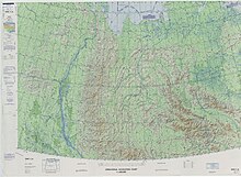
The Lena flows north-east and traverses the Lena-Angara Plateau, then is joined by three tributary rivers: (i) the Kirenga, (ii) the Vitim, and (iii) the Olyokma.
Travelling approximately due north, the Lena widens into a great river delta that merges into the Laptev Sea, a marginal region of the Arctic Ocean, south-west of the New Siberian Islands.
The Lena Delta is 30,000 square kilometres (12,000 sq mi) in area,[7] being traversed by seven main branches, the most important being the Bykovsky channel, farthest east.
[8] The area of the Lena River basin is calculated at 2,490,000 square kilometres (960,000 sq mi) and the mean annual discharge is 489 cubic kilometers per year.
According to folktales related a century later, in the years 1620–1623 a party of Russian fur hunters under the leadership of Demid Pyanda sailed up Nizhnyaya Tunguska, discovered the Lena, and either carried their boats there or built new ones.
Of the group led by Captain George W. De Long, only two of the men survived; the others died of starvation.
The Lena massacre was the name given to the 1912 shooting-down of striking goldminers and local citizens who protested at the working conditions in the mine near Bodaybo in northern Irkutsk.
The incident was reported in the Duma (parliament) by Kerensky and is credited with stimulating revolutionary feeling in Russia.
Vladimir Ilyich Ulyanov, when he was exiled to the Central Siberian Plateau, may have taken his alias, Lenin, from the Lena River.