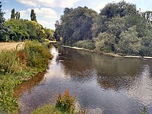
River Mole
It rises in West Sussex near Gatwick Airport and flows north-west through Surrey for 80 km (50 miles) to the Thames at Hampton Court Palace.
[1][3] Twelve Sites of Special Scientific Interest (SSSIs) that include wetland habitats are located within the Mole catchment area, and the stretch of river through Leatherhead has been designated a Local Nature Reserve.
It flows initially southwards for 1 km (0.6 mi) to a small lake at Baldhorns Park, before running eastwards through a largely rural area towards Crawley.
[15][16] The Mole enters Surrey to the south of Horley, where it meets the Gatwick Stream, a tributary draining Worth Forest to the southeast of Crawley.
0.7 km (0.4 mi) south of Sidlow the mean flow is measured as 2.21 m3/s (78 cu ft/s) at Kinnersley Manor gauging station (48 m [157 ft] above OD).
A number of minor tributaries join the river from the west and are typically second order streams draining the woodland and arable land between Horsham and Dorking.
The course of the river through Norbury Park was partially straightened when the Epsom to Horsham railway was built in 1837, with the removal of a small meander north of Westhumble.
Prior to the last ice age, the River Thames followed a more northerly route to the North Sea, from Reading via Marlow, Chorleywood, St Albans, Hertford and along the present Suffolk–Essex border.
[27] During this period, the Mole is thought to have merged with the River Wey near Byfleet and then flowed in a north-easterly direction via Richmond to meet the proto-Thames near Ware in Hertfordshire.
During the Middle Pleistocene period,[note 6] a large ice sheet built up across much of the East of England, reaching as far south as St Albans and Chelmsford, blocking the path of the proto-Thames.
Glacial meltwater from the Anglian ice sheet caused the Thames to divert southwards and flood the valley of the Mole–Wey river, thus adopting its present route through London.
[29] In 1972 a sub-debate on the future cleanliness of the Mole was had by the House of Lords, involving a member of the South-East Strategic Committee of the Thames Conservancy (succeeded by the Environment Agency) and four others.
In 2003, the upper River Mole near Meath Green Lane, Horley, was enhanced to create a gravel spawning area to encourage chub and dace in addition to roach.
The Ember flood relief channel has a diverse fish population, including chub, dace, roach, bleak, large pike and barbel.
Crayfish are common in areas associated with high alkalinity, particularly around Brockham, and the tributaries which run over the Weald Clay provide an excellent habitat for stoneflies, caddisflies, fast swimming mayflies and riffle beetles.
The geology of the local area is complex, since the river leaves the chalk of the Mole Gap at this point and flows over gravel and clay, creating a patchwork of different habitats including scrub, woodland, hedges, banks, and meadows as well as the water itself.
Plant species typical of ancient woodland are found in this area, including bluebells (Hyacinthoides non-scriptus), marsh marigolds (Caltha palustris) and golden saxifrages (Chrysosplenium sp.).
[6] From the source to Dorking, the river drains an area of 340 km2 (130 sq mi), of which approximately 60% is on Wealden or Atherfield Clay, 20% is on Tunbridge Wells Sand and 20% is on greensand.
[2] Between Dorking and Leatherhead the Mole cuts a steep-sided valley through the North Downs, creating a 170-metre-high (560 ft) river cliff on the western flank of Box Hill.
[47] In a survey in 1958, the geologist C. C. Fagg identified 25 active swallow holes between Dorking and Mickleham; the majority were only a few centimetres in diameter and were located in the vertical banks of the river below the water line.
However this proved to be impractical and they were instead covered by concrete domes, up to 18 m in diameter, each fully supported by the surrounding chalk and provided with a manhole and access shaft to allow periodic inspection.
[74] The Mole Gap and North Downs do not appear to have been settled until the late Stone Age: A large axe, typical of a "rough-out" axe produced during the Neolithic period, which was discovered in 1952 during building work in Westhumble,[75] A flint mine of the same period has been discovered at East Horsley along with Neolithic flakes of flint at Fetcham and Headley Heath.
[78] It is not clear to what extent the Mole was used for navigation in the past: In the late 13th century, Thorncroft Manor (south of Leatherhead) purchased a shout, a type of boat up to 16 metres (52 ft) in length used to carry produce to market[79] and it has been suggested that stone cut from quarries in Reigate was transported to London via the river.
[81] In 1798 William Marshall advocated the canalisation of a short stretch of the River Mole between Betchworth and Dorking to facilitate the movement of chalk from quarry to market.
[81] Between 1825 and 1828 the architect and civil engineer Nicholas Wilcox Cundy proposed a Grand Imperial Ship Canal from Deptford to Chichester passing through the Mole Gap, however he was unable to attract sufficient financial interest in his scheme.
At Boxhill Farm, where access to the river from the north bank was required for the herd of dairy cows, a row of twelve concrete cylinders were cast as an anti-tank measure.
Concrete anti-tank dragon's teeth were built on both sides of the river, a short distance upstream of the bridge, as an obstacle to armoured vehicles.
When the Burford Bridge was rebuilt in 1937, excavations revealed a "flint-surfaced approach to [a] ford at low level having all the signs of Roman workmanship" suggesting that Stane Street (which ran from London to Chichester via Dorking) crossed the river at this point.
The bridge is a long structure of 14 segmental arches resting on low piers, finished in red brick in Flemish bond, with some Portland stone dressing.
[22][50] In The Faerie Queene (first published in 1590) Edmund Spenser wrote of the river: In Poly-Olbion (first published in 1612) the poet Michael Drayton described the journey taken by the River Thames to the sea: He writes in the appendix to Song XVII This Mole runnes into the earth, about a mile from Darking in Surrey, and after some two miles sees the light againe, which to be certaine hath been affirmed by Inhabitants thereabout reporting triall made of it.