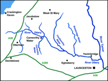
River Ottery
"[4] With its tributaries, the River Ottery forms a major sub-catchment of the Tamar system, draining 48 square miles (120 km2) of north Cornwall.
The Ottery's catchment area is within the Carboniferous geological formation known as the Culm Measures which stretches from Dartmoor to north Devon and across northeast Cornwall as far west as Bodmin Moor.
The River Ottery system was severely affected by flooding in north Cornwall on 16 August 2004 when up to eight inches of rain fell during a single afternoon.
[7][8] The project's page also notes: "The Ottery supports a broad range of wildlife including populations of trout and migratory fish, otters, kingfishers, sand martins, dippers, curlews, snipe and the marsh fritillary butterfly.
However, the part of Cornwall north of the River Ottery has few place-names including tre- and far more of Old English origin (such as those ending in -dun and -cot) than the rest of the county.