Seine
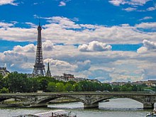
[3] It rises at Source-Seine, 30 kilometres (19 mi) northwest of Dijon in northeastern France in the Langres plateau, flowing through Paris and into the English Channel at Le Havre (and Honfleur on the left bank).
Small statues of the dea Sequana "Seine goddess" and other ex-votos found at the same place are now exhibited in the Dijon archaeological museum.
[8] The river is only 24 metres (79 ft) above sea level 446 kilometres (277 mi) from its mouth, making it slow flowing and thus easily navigable.
Smaller locks at Bougival and at Suresnes lift the vessels to the level of the river in Paris, where the junction with the Canal Saint-Martin is located.
Until locks were installed to raise the level in the 1800s, the river was much shallower within the city, and consisted of a small channel of continuous flow bordered by sandy banks (depicted in many illustrations of the period).
Today the depth is tightly controlled and the entire width of the river between the built-up banks on either side is normally filled with water.
[17] A 2002 report by the French government stated the worst-case Seine flood scenario would cost 10 billion euros and cut telephone service for a million Parisians, leaving 200,000 without electricity and 100,000 without gas.
Tributaries of the Seine are, from source to mouth:[2] Due to concentrated levels of industry, agriculture and urban populations of Paris and its surroundings, the Seine-Normandy watershed experiences the highest human impacts of any hydrographic basin in France.
Compared to most other large European rivers, the ability of the Seine to dilute urban sewage and farmland runoff is very low.
Low oxygen levels, high concentrations of ammonia, nitrites and faecal bacteria, extending from Paris to the estuary, have been issues for over a century.
The advent of nitrogenous fertilizers in the 1960s marked an upturn in agricultural pollution due to land use changes that had previously scaled with population growth.
Large-scale construction of waste water treatment plants (WWTPs) began in 1940 to meet demand; however, by 1970, about 60% of urban sewage was allowed to flow into the river untreated.
Measures taken in the early 2000s due to the Water Framework Directive led to significant reductions of organic carbon, phosphorus and ammonium, which in turn decreased the occurrence and severity of phytoplankton blooms.
This is due in large part to Paris' "single system" drainage scheme dating from the 19th century, which combines street runoff and sewage.
Plans also call for several public swimming areas to be made available by 2025, ending a ban instituted in 1923 due to the polluted water.
[35] During the Summer Olympics, the date of the triathlon was postponed due to water quality issues,[36] as the earlier rainstorm during the opening ceremony had driven some untreated rainwater back into the Seine.
Sometimes it is incorrectly associated with Latin sequor 'follow', but the Celtic word rather seems to derive from the same root as English sea, namely Proto-Indo-European *seikw-, signifying 'to flow' or 'to pour forth'.
[40] After the burning of Joan of Arc in 1431, her ashes were thrown into the Seine from the medieval stone Mathilde Bridge at Rouen, though unsupported counter-claims persist.
[41] On 9 August 1803 Robert Fulton, American painter and marine engineer, made his first successful test of his steamboat in the Seine beside the Tuileries Garden.
Having a length of sixty-six feet and an eight-foot beam Fulton's steamboat attained speeds of three to four miles per hour against the Seine's current.
[47] During the Olympics, daily tests of the water quality were taken to determine if it was safe for swimming; this caused the triathlon to be delayed by a day, before being allowed to proceed on July 31.