Riverfront Park (Spokane, Washington)
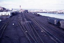
In 1972, the active railyards were removed, and the area around the Spokane Falls reclaimed, when construction commenced on an urban renewal project that built a fairground to host the upcoming environmentally-themed Expo '74 World's fair.
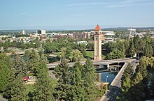
[18] Moving northward across the South Channel is Havermale Island which encompasses a number of grassy meadows, natural conservation areas, amphitheaters, the U.S. Pavilion, and the Great Northern clock tower.
[47][48] Along the falls, the salmon would be caught using various fish trap methods and the catch would be dried and smoked on site to preserve and store them for sustenance during the sparse winter months.
[41][49] In 1873, James N. Glover, who would go on to become influential in the initial birth and growth of Spokane and is considered one of its founders, passed through the region with his business partner Jasper N. Matheney.
The group would hire New York-based Ebasco Services to create an urban renewal plan, which was released in 1961 and called for the removal of the numerous train tracks and trestles in downtown and reclaiming the attractiveness of the Spokane River in the central business district.
[46][61][62][64] The railroads were consolidated onto the Northern Pacific Railway lines further to the south in downtown Spokane,[55] freeing up the site for construction to transform it to host the environmentally-themed Expo '74.
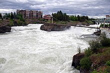
[46][69] Perron sought to accentuate the site's natural features such as the upper and lower falls by utilizing observation points that were previously occupied by industrial buildings and warehouses, train tracks, and parking lots.
Flowing footpaths connect the various sites and follow the terraformed landscape, revealing elements and viewpoints around the edges of the park, at the center of which is a natural amphitheater.
[78] The advisory committee hired Olson Kundig Architects to conceptualize the design of the new structures and grounds within the framework of the master plan and with input from stakeholders.
Marmots are common in and around the river, the park, the Centennial Trail, and other areas around the city, which is unusual outside the region as they typically live in more remote, mountainous locations.
It stated that the theme of the fair was of great national importance and interest, and that participation would help provide a platform to showcase the country's accomplishments in the environmental field on a world stage.
Three finalists were eventually named, with Los Angeles-based Herb Rosenthal & Associates being awarded the contract to develop the plan, including schematic concepts and cost estimates.
[112] The design of the pavilion was described by the U. S. Department of Commerce as "an expression of environmental concern...[with the] structure's smooth, graceful contour harmonized fully with the surrounding shoreline terrain.
The Commerce Department was short-staffed and experiencing a heavy workload at the time, and its base in Washington, D.C. was considered too remote to Spokane to run the construction successfully.
[114] Due to time constraints, the GSA decided to use a phased-bid project delivery method so that as soon as the architects completed a portion of the design, it could be put out to bid for construction.
Instead, several dozen panels mounted on the west side of the cable structure create shade for portions of the renovated pavilion's floor and seating areas.
[122] Spokane's carousel, which was added to the National Register of Historic Places in 1977,[123] and still operates for riders today, was built in 1909 as a wedding gift from Looff to his daughter Emma and her husband Louis Vogel.
When Expo '74 came, organizers originally wanted to bring the carousel out of storage and showcase it to the world during the event, but it was deemed impractical due to the restoration and moving costs.
The building that housed the German Hofbrau during the world's fair became the new home for the carousel,[1][125] and it operated in there until 2016[124] when the ride temporarily closed for Riverfront Park's redevelopment.
The Red Wagon is located along Spokane Falls Boulevard on Riverfront Park's southern boundary, between the First Interstate Center for the Arts and the Looff Carousel, and diagonally across from the Davenport Grand Hotel.
[147] The climbing wall, which is supposed to represent the ice dam, that caused the ice age floods bears a quote from geologist J Harlen Bretz, who is credited with the then-controversial theory of the ice age floods that created the regions unique geography amid decades of skepticism from the scientific community, the quote reads: "I could conceive of no geological process of erosion to make this topography, except huge, violent rivers of glacial melt water..."[25] In the center of the play area is the Roskelley Performance Climbing Boulder, a climbing rock dedicated to mountaineer and Spokane native, Jess Roskelley, who died in an avalanche in 2019 while descending Howse Peak in Alberta; in addition to bearing his name, the rock has his life motto inscribed on it: "fortitudine vincimus" or "by endurance, we conquer" in Latin.
[147] The City of Spokane announced plans for a dog park to be located on Havermale Island and incorporating the existing Expo '74 forestry shelter in February 2022.
[156] During the major redevelopment of the park for its 50th anniversary, two additional standalone works were commissioned, The Seeking Place by Sarah Thompson Moore and Stepwall by Meejin Yoon.
Its creation and installation was sponsored by the Spokane Women's Council of Realtors and sculpted by Sister Paula Mary Turnbull, a local nun and leading figure in the Inland Northwest arts scene.
[159] As its name suggests, the corten steel[153] sculpture was modeled after a goat and features a vacuum mechanism that sucks up small pieces of garbage through its mouth, allowing users to "feed" it.
[160] The goat has an unofficial Facebook page with thousands of followers[161] and the Spokane County Regional Solid Waste System has its public educational outreach blog named after it.
[170] Running from A Place of Truth Plaza near city hall to Glover Field Park in Peaceful Valley, under the Monroe Street Bridge, the zip line would span 1,400 feet.
[52] A 30-kW plant from Edison was soon purchased and installed on the Spokane River's North Channel along the Post Street Bridge,[172][173][52] which today forms the western boundary of Riverfront Park, and powered among other things, the city's first opera.
[52] Many, including Edison himself, began to favor the output consistency of steam power, which was not dependent on the highly-variable flow of a river, as the future of electricity generation.
The calm water enables many of these attractions, including the steps and floating stage[185][186] at the First Interstate Center, as well as the lowered viewing platforms on the South Channel Bridge[187] allowing visitors to interact with the river.