Road signs in the United Kingdom
In addition, it was the cycling lobby that successfully pressured the government in 1888 into vesting ownership of and responsibility for roads with county councils in previously established highway districts that would be funded from taxation rather than tolls.
Under the Motor Car Act 1903 four national signs were created which were to be set at least 8 ft (2.4 m) from the ground and 50 yards (46 m) from their reference point.
The latter two could provide more detail by having an information plate below them, but often it was left to the motorist to guess what the sign was referring to, and it was common to have variations between different local areas for what was a prohibition or just a "notice".
[2] Following a review of national signage in 1921, a limited number of warning and hazard information plates also used symbols, rather than only text.
As part of its anti-invasion preparations during World War II, the British government instructed all navigational signposts and railway station signs to be removed, so as not to aid potential enemy ground movements.
[3] After the war ended, larger motoring associations embarked upon a programme to erect temporary road signs.
These temporary signs, which were not required to conform to the standardisation laid down by the government, usually displayed the motoring association’s logo and colour-scheme.
Some road signs were subject to minor modification, mainly in the early post-World War II years.
Meanwhile, the triangle was inverted for 'HALT' and 'SLOW', while 'NO ENTRY' became a combination sign - a red disc bisected by a horizontal white rectangle bearing the lettering.
Cast signs were designed to be maintained by being repainted with the raised lettering and symbol easily picked out by an untrained hand.
In the 1950s cast signs were quickly displaced by sheet metal (usually aluminium) coated with adhesive plastics; these could be made reflective, famously by Scotchlite.
The sizes of borders, symbols and arrows and the spacing and layout of the sign face are expressed in sw, so that all the elements remain in proportion.
On Advance Direction Signs, as introduced under the Guildford Rules, the background colour indicates the category of route on which it is located.
In addition to the national colour schemes, the park also uses white signs with a light blue border and text to denote routes suitable for medium-sized vehicles and white signs with a brown border and text for routes suitable for cars and small vehicles only.
Although signs containing other typefaces do appear occasionally in some places, they are explicitly forbidden in government guidelines and are technically illegal.
[16] Bilingual signs were permitted by special authorisation after 1965, and in 1972 the Bowen Committee recommended that they should be provided systematically throughout Wales.
They give the UK standard speed limits and remind drivers to drive on the left, in English, French, and German.
This is part of the Gaelic language revival encouraged by many, including the Scottish Government and Bòrd na Gàidhlig.
Examples below exclude low bridges, railway and tramway level crossings, bus and pedal cycle facilities, traffic calming and road works.
Bridges particularly at risk from strikes may have a variable message sign that is activated by high vehicles passing through an infra-red beam.
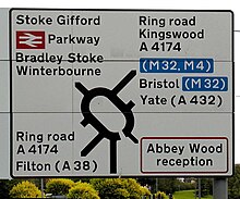
[22] An advance direction sign (ADS)[22] generally has blue, green or white as its background colour to indicate the status of a road (motorway, primary or non-primary) on which it is placed.
Except on the main carriageway of a motorway, coloured panels are used to indicate routes from the junction being signed that have a different status.
A direction sign (DS)[22] should always be a single colour indicating the status of the road to be joined, although there are a few rare exceptions to this rule.
On a roundabout DS, the route locations are usually listed with the closest destination at the bottom and the furthest away at the top when going straight ahead, and likewise going left and right.
All types of ADS (but not DS) may optionally have the junction name at the top of the sign in capital letters in a separate panel.
[23]Diversion routes are marked with black symbols on a yellow patch (square, triangle, circle, or diamond).
In many areas, the sign will also show the name of the local authority, its coat of arms, or part of the street’s postcode.
However, for administrative and maintenance purposes, distance marker posts and driver location signs have been erected on motorways and certain dual carriageways.
One of the consequences of this partial incorporation is that while in England and Wales speed limit signs had to appear on both sides of a carriageway until 2016, this was not necessary for the Isle of Man.
The British Indian Ocean Territory's road signs are modelled on those of the United States' Manual on Uniform Traffic Control Devices.