Roaring Fork (Great Smoky Mountains)
While the stream presents as a peaceful trickle on any given day, it quickly becomes a raging whitewater rapid after a mild rain shower.
The source of Roaring Fork is located nearly 5,000 feet (1,500 m) up along the northern slopes of Mount Le Conte, where several small springs converge.
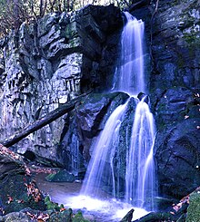
[2] From its source, Roaring Fork drops 2,500 feet (760 m) over just two miles (3.2 km), spilling over Grotto Falls and absorbing Surry Creek before steadying in a narrow valley between Mount Winnesoka and Piney Mountain.
The Roaring Fork valley is underlain by Precambrian sandstone of the Ocoee Supergroup, a rock formation formed from ancient ocean sediments nearly a billion years ago.
Roaring Fork Sandstone is found throughout the mid-level elevations of the northern Smokies and is especially common in Greenbrier to the east and the Sugarlands to the west.
Richard Reagan (1776–1829), the son of one of these pioneers, settled on a large plot of land just south of Gatlinburg along LeConte Creek.
Some of Reagan's children settled to the west in the Sugarlands, while some of them moved east to the hollow along Roaring Fork, which was then known as "Spruce Flats."
[6] Uppermost on Roaring Fork, near where the stream absorbs Surry Creek, were farms owned by the Clabo family, Gilbert Ogle, and Jasper Mellinger.
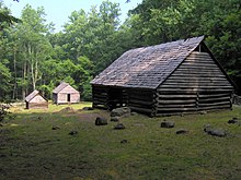
A rock wall and paling fence behind the cabin are representative of the two major barriers used in the northern Smokies in the late 19th and early 20th centuries.
Reagan was a jack-of-all-trades, operating the Roaring Fork community's blacksmith shop, general store, and its most consistent grist mill.
Built by mountain guide Albert Alexander Cole, it has been moved from its original site to the Jim Bales Place along the Roaring Fork Motor Nature Trail.
[16][17] The Roaring Fork Motor Nature Trail is a narrow one-way road that is open to vehicular traffic (cars and small pickup trucks only) in spring, summer, and fall.
This hiking trail leads past Grotto Falls and Trillium Gap en route to the summit of Mount Le Conte.
Trillium Gap—the gap between Brushy Mountain and the main Le Conte massif—was named by Horace Albright, who observed the trillium-filled area in the 1920s.
The road continues to descend past the historic district, passing along the way a parking lot that allows for a view of Roaring Fork.