Roaring Spring, Pennsylvania
After 1867, as the paper mill expanded, surrounding tracts of land were acquired to accommodate housing development for new workers.
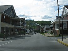
As a result, the seemingly random street pattern of the historic district is the product of hilly topography, a small network of pre-existing country roads that converged near the Big Spring, and the property lines of adjacent tracts that were acquired through the years for community expansion.
The boundaries of the district essentially include those portions of Roaring Spring Borough which had been laid out for development by the early 1920s.
Since the district's period of significance extends to 1944, most of those buildings erected after the 1920s were built as infill within the areas already subdivided by the 1920s.
In the early 1960s, the borough began to annex sections of adjacent Taylor Township, especially to the east around the then new Rt.
By 1873, the borough contained about 170 lots and 50 buildings, which included the paper and grist mills, three churches, a company store, a schoolhouse, and one hotel.
The triangle remained the industrial, commercial and retailing core of the town until 1957 when the bypass of Main Street, PA Rt.
The village core retains only a few shops and professional offices, but still holds the Roaring Spring Blank Book Company and Roaring Spring Water Bottling Company, all of the historic church buildings, the public library(formerly the Eldon Inn), the borough building, the post office(earlier moved from farther up East Main St.).
[7] According to the United States Census Bureau, the borough has a total area of 0.8 square miles (2.1 km2), all land.
The district serves Taylor, Freedom, Huston, and North Woodbury Townships as well as the towns of Roaring Spring and Martinsburg.