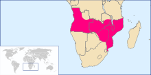
Pink Map
Portuguese Angola consisted of areas around Luanda and Benguela, and a few almost independent towns over which Portugal claimed suzerainty, the most northerly being Ambriz.
This was facilitated first by the development of coffee plantations in southern Brazil from the 1790s onward, and second by the 1815 and 1817 agreements between the United Kingdom and Portugal limiting—at least on paper—Portuguese slave trading to areas south of the equator.
Although Delagoa Bay was regarded as Portuguese territory, Lourenço Marques was not settled until 1781, and was temporarily abandoned after a 1796 French raid.
[14] Zumbo was abandoned in 1836 and the Gaza Empire forced Afro-Portuguese settlers near Vila de Sena to pay tribute.
[15] Although Portugal claimed sovereignty over Angoche and a number of smaller Muslim coastal towns, these were virtually independent at the start of the 19th century.
[16] Portugal also initiated the Prazo system of large leased estates under nominal Portuguese rule in the Zambezi valley.
By the end of the 18th century, the valleys of the Zambezi and lower Shire River were controlled by a few families who claimed to be Portuguese subjects but who were virtually independent.
Under Mzila the centre of Gaza power moved north to central Mozambique and came into conflict with the prazo owners who were expanding south from the Zambezi valley.
[19] As in Angola, during the 18th century Afro-Portuguese traders employed by the Mozambican prazo owners penetrated inland from the Zambezi valley as far as Kazembe in search of ivory and copper.
In 1798 Francisco de Lacerda, a Portuguese officer based in Mozambique, organised an expedition from Tete to the interior hoping to reach Kazembe, but he died en route in what is now Zambia.
Even Lacerda's expedition was largely commercial in purpose, although it was later declared by the Lisbon Geographical Society to have established claim to the area it covered.
The Portuguese government was suspicious of exploration by other European nations, particularly those whose leasers held an official (often consular) position as Livingstone had, which their home countries could use to claim territory Portugal regarded as its own.
[24] Although Minister of Foreign Affairs Andrade Corvo doubted Portugal's ability to achieve coast-to-coast empire, he sanctioned expeditions.
Portuguese soldier and explorer Alexandre de Serpa Pinto led three such expeditions through which Portugal could attempt to assert its African territorial claims.
[27] The 1879 treaty was never ratified, and in 1882 Portugal occupied the lower Shire River valley as far as the Ruo, after which its government again asked Britain to accept this territorial claim, without success.
[28] Further bilateral negotiations led to a draft treaty in February 1884, which would have included British recognition of Portuguese sovereignty over the mouth of the Congo in exchange for freedom of navigation on the Congo and Zambezi rivers, but the Berlin Conference of 1884–85 ended these discussions which could have led to British recognition of Portuguese influence stretching across the continent.
[33] The General Act of the Berlin Conference dated 26 February 1885 introduced the principle of effective occupation, potentially damaging Portuguese claims, particularly in Mozambique where other powers were active.
Article 34 required a nation acquiring land on the coasts of Africa outside of its previous possessions to notify the other signatories of the Act so they could protest such claims.
[34][35] British officials did not accept this interpretation and in January 1884 Henry E. O'Neill, the British consul based at Mozambique Island, stated: To speak of Portuguese colonies in East Africa is to speak of a mere fiction—a fiction colourably sustained by a few scattered seaboard settlements, beyond whose narrow littoral and local limits colonisation and government have no existence.
Andrada obtained treaties over much of this area and established a rudimentary administration before he was arrested and expelled in November 1890 by the British South Africa Police (BSAP).
Despite the outcome of the Berlin Conference and failed bilateral negotiations with Britain, Portugal continued pursuing a contiguous, transcontinental colonial territory.
[41][42] British Prime Minister Lord Salisbury formally protested the Rose-Coloured Map, but initially made no claim to the territories it represented.
[45] Later popular perception in Britain suggested the Rose-Coloured Map was a direct challenge to Cecil Rhodes's vision of a "Cape to Cairo Red Line".
The Cape to Cairo idea was first put forward by Henry "Harry" Hamilton Johnston in an August 1888 newspaper article three years after the Pink Map's publication and only later adopted by Rhodes.
[47] North of the Zambezi, Portuguese claims to the Shire Highlands were opposed by the African Lakes Company and the missionaries, the latter supported by public opinion, especially in Scotland.
[50] Serpa Pinto's expedition was well armed, partly in response to a Portuguese resident's request for help in resolving disturbances caused by the Makololo chiefs on the lower Shire River.
[57] Historians have argued that Lord Salisbury's diplomatically isolated government used tactics that could have led to war because they feared humiliation from Portuguese success.
Between the British issuing the ultimatum and the signing of a treaty in Lisbon on 11 June 1891, both Britain and Portugal tried to occupy more of the disputed areas and assert their authority.
The British government refused to accept existing Portuguese administration; fighting only stopped when Rhodes's company was awarded part of Manicaland.
[59] This treaty did grant Portugal rights to build a railway, road, and telegraph line along the Zambezi River's north bank, which would have provided a limited link between Angola and Mozambique.