Ruislip
The manor of Ruislip appears in the Domesday Book, and some of the earliest settlements still exist today, designated as local heritage sites.
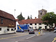
The buildings at the northern end of Ruislip High Street form the core of the original village square and are now Grade II listed.
At the time of Edward the Confessor, the manors of Ruislip and Ickenham belonged to a Saxon named Wulfward White,[2] a thane of the king who owned land in 11 counties.
[3] Wulfward lost much of his land during the Norman conquest of England; Arnulf de Hesdin took control of Ruislip – his ownership is recorded within the 1086 Domesday Book.
[7]Under Edward the Confessor, Ruislip had been valued at £30, though the reduction to £12 by the time Ernulf de Hesdin took possession is believed to have been caused by a passing unit of the Norman Army taking crops.
[8] Before leaving England to fight in the Holy Lands, Ernulf de Hesdin gave ownership of Ruislip to the Benedictine Bec Abbey in 1087.
He died fighting and is commemorated in annual masses held in June at Sacred Heart Church and on the remains of the motte-and-bailey at Manor Farm.
[9] The present church is said to have been built upon the insistence of the Proctor-General, William de Guineville, under the ownership of Bec Abbey, to serve the growing population.
Councillors were also aware that King's College, Cambridge, owners of much of the land in the parish and lords of the manor, were planning to sell some for development.
In particular, the Poplars, a Georgian house built in 1774 on the corner of the High Street and Ickenham Road, opened a tea garden in the grounds.
[22] The district experienced a sharp rise in population, from 6,217 in 1911 to 72,791 in 1961, caused by the extension of the Metropolitan Railway, termed Metro-land, which brought with it an increase in suburban house building.
Members of the council had already raised concerns over some of the new building work around Eastcote and South Ruislip, and the new development near Northwood station which they described as "badly arranged and closely-packed".
Many of the woods and historic sites including Manor Farm were to be demolished and cleared as part of the plan, making way for a projected total of 7,642 homes, enough for 35,000 residents.
A Local Board[clarification needed] inquiry followed on 17 February 1911 which required negotiations with landowners to allow for a full planning scheme to be compiled.
This was presented in February 1913 with an adaptation of the original Soutars plan, receiving approval from the Local Government Board in September 1914.
Three roads with residential housing, Manor Way, Windmill Way and Park Way were completed before the outbreak of the First World War when all construction work was halted.
[24] Manor Farm and the local woods eventually avoided demolition in January 1930, after the visit by a member of the Royal Society of Arts to choose the buildings that should be conserved.
[25] King's had wished to also present the wood as a gift but was required by the University and Colleges Act to receive payment as it was the trustee of the land.
[27] On 19 December 1946 a Railway Air Services Dakota 3 airliner taking-off from Northolt Aerodrome crashed into a house in Angus Drive, Ruislip, fortunately with no serious injuries to anyone, either in the aircraft or on the ground.
On 6 January 1948 a British European Airways Vickers VC.1 Viking flying from Renfrew Airport to RAF Northolt crashed in a ploughed field approximately five miles from the runway.
The Krogers were eventually arrested and found to have codes, a microdot reader and film of the Admiralty Underwater Weapons Establishment in Portland Harbour concealed within ordinary household items.
The house became a college in 1948 and included plaques with the crests of all Royal Air Force squadrons involved in the Battle of Britain as a memorial.
between 1938 and 2008, (when the ground was known by a different name)[citation needed] before the non-league club folded following a period of financial uncertainty during its latter two trading years.
Ruislip Golf Course, on Ickenham Road, was opened in 1922, and is operated by a private company on behalf of the London Borough of Hillingdon.
The venue opened its doors in 2017 and its first match was a Connacht Senior Football Championship quarter-final clash between London and Leitrim.
The village water pump was sunk in the centre of the square in 1864, to a depth of 105 feet (32 m) 9 inches (230 mm), though was moved to be beside the Manor Farm Lodge in the 1970s.
Work began in 1811; the consulting engineer John Rennie announced completion of the project to the Grand Junction Waterworks Company on 5 December that year.
Following the extension of the Metropolitan Railway to Ruislip, and the resulting influx of visitors to the area, Albert Cross built a bungalow from where teas were served to day-trippers.
In one scene, a title card states "When Tom was in the money, the world was our oyster, and we chose Ruislip" before cutting to an aerial view of a large council estate.
[71][72] The now demolished Punch and Judy cafe on Ducks Hill Road was the location for Dave Allen's bank note under a car sketch.