Norway–Russia border
[2] Religiously motivated Russian colonization of the jointly taxed areas started in the 16th century, and Russian-Orthodox chapels were built at Neiden, Pechenga and Boris Gleb.
Norway joined a union with Sweden in 1814 and two years later King Carl John again tried to start negotiations, without success.
In 1825, however, a common Norwegian and Russian commission was established to draw a border line, resulting in a report and a map which was approved by both countries' authorities.
[1] During Operation Barbarossa, the Axis invasion of the Soviet Union in World War II, northern Norway served as the staging area for the German attack on Murmansk.
The Soviet Union made an excursion over the border in 1944 in the Petsamo–Kirkenes Offensive which aimed to extinguish the German military forces in the area.
The idea initially met resistance from Norwegian authorities of cost reasons, but they soon agreed on the principle to reduce unintentional border crossings.
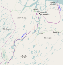
The thalweg line would create problems for the settlement at Grense Jakobselv, as they no longer would be able to use their harbor or have free access to the sea.
[12] The countries therefore agreed on a new line based on a Norwegian proposal, in exchange for the Soviet Union receiving three islets, including Kistholmen and Brennholmen, in the Pasvik River.
[21] The area on both sides of the river saw an increased industrialization, especially Sydvaranger in Norway and Pechenganikel (now, part of MMC Norilsk Nickel) in Russia.
An agreement was signed in 1957 which would result in the construction of four power stations, the Paatsjoki River Hydroelectric Plants, of which two were owned by each of the countries.
[22] Up until the power plants opened the river had been used for log driving from Finland to the sawmill at Elvenes, which was permitted according to the border treaty.
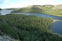
[25] (there was a war between the Soviet Union and German controlled Norway which much affected this area) Proposals for conservation of the Norwegian part of Pasvikdalen was first launched by Carl Schøyen in 1936.
[28] In the late 1970s Norway, inspired by Finland, considered replacing the wooden poles with fibreglass as this would make them more durable and reduce maintenance.
However, the authorities concluded that wooden poles were more suitable and more durable in relation to human contact, as Norway, unlike Russia and Finland, allows people to travel up to the border.
[41] From the Norwegian side, the agreement was negotiated by Labour Party politician Jens Evensen and his protégé Arne Treholt, who was later exposed as a Soviet spy and convicted of high treason.
[44] The arrest and conviction of Treholt in 1984 and 1985 had a devastating effect on Evensen, who withdrew completely from public life in Norway.
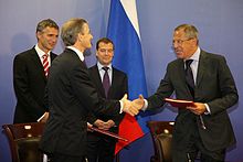
[46] During a meeting in Oslo on 27 April 2010, President of Russia Dmitry Medvedev and Prime Minister of Norway Jens Stoltenberg announced that the territorial dispute in the Barents Sea was settled.
[47][48] The agreement is a compromise which divides a disputed area of around 175,000 square kilometers (68,000 sq mi) into two approximately equally sized parts.
[51] On 30 March, Russia's State Duma also voted in support of ratification, despite strong opposition from Communist Party representatives.
[49][52][54][55][56] The border treaty is economically significant, as it makes possible to conduct geological surveys and hydrocarbons drilling in the formerly disputed area, which is estimated to contain up to 6.8 billion tons of oil and gas.
The Norwegian markers are yellow with a 18 centimeters (7.1 in) tall black top—this was chosen because it would be most visible in all types of weather and lighting.
[24] The fence stretches the entire distance between the Barents Sea and the Gulf of Finland and was built during the Cold War to keep in the population of the Soviet Union.
[24] Photography from one country into the other is only permitted if the pictures do not include military personnel and installations, that tripods are not used and not using longer than 200 mm lenses.
There is one legal border crossing point, with stations on both sides, at Storskog in Norway and Borisoglebsky in Russia, located on the E105 highway some 15 km east of Kirkenes.
[66] Since 29 September 2017, a new bridge has been opened passing the Pasvik river, with the Storskog-Borisoglebsk customs stations still handling the travels between the two countries.
There are five main motivations for trans-border traffic: shopping in border towns, business, vacation and leisure, visiting friends and relatives, and transfer to other destinations via Kirkenes Airport, Høybuktmoen.
[79] There is a special (almost) visa-free arrangement for a designated area of between 30 and 50 kilometres (19 and 31 mi) surrounding the border, based on a clause in the Schengen Agreement.
It is only available for residents of the zone for the past three years and requires that a special ID-card be acquired from the consulate of the country to visit (a kind of multiple-journey visa).
The Parliament of Norway's Standing Committee on Foreign Affairs and Defence has taken initiative to introduce a 24-hour-a-day opening time at the crossing; this has been rejected by the local police district, who stated that nearly all trans-border traffic is persons and that there is hardly any demand for a night service.
[90] In 2007, Murmansk Oblast's governor, Yury Yevdokimov, rejected the plans for a connection to Russia, stating that his opinion was supported by President Vladimir Putin.