Sabancaya
Sabancaya is an active stratovolcano in the Andes of southern Peru, about 70 kilometres (43 mi) northwest of Arequipa.
The Central Volcanic Zone includes a number of volcanoes, some of which like Huaynaputina have had large eruptions and others such as Sabancaya and Ubinas have been active in historical time.
The name "Sabancaya" is Quechua and means tongue of fire[1] or spitting volcano, likely a reference to the eruptive activity.
[9] Many volcanoes in the Central Volcanic Zone are poorly known, owing to their remote locations and adverse conditions such as high altitude.
[7] Sabancaya is part of a series of volcanoes that line the southwestern coast of Peru at a distance of roughly 100 kilometres (62 mi) from the shore.
[11][10] All these volcanoes are considered part of the Central Volcanic Zone of the Andes,[12] and lie c. 150–200 kilometres (93–124 mi) east of the Peru-Chile Trench.
[13] Notable among them are Ampato and Coropuna for exceeding a height of 6,000 metres (20,000 ft), Huaynaputina and El Misti for their large eruptions and Ubinas and Sabancaya for their recent activity.
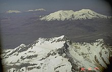
[6] Sabancaya, like its two neighbours, is covered by an ice cap[2] which in 1988 extended to distances of 2.5–3 kilometres (1.6–1.9 mi) from the summit.
[38] Moraines at elevations of 4,450–4,250 metres (14,600–13,940 ft) above sea level testify to the occurrence of more extensive glaciation during the last ice age between 25,000 and 17,000 years before present,[39] when ice covered an area of 347 square kilometres (134 sq mi) on the three volcanoes;[33] these moraines have diverted some lava flows.
[24] Younger moraines are found at higher altitudes, 4,400–4,650 metres (14,440–15,260 ft) above sea level, and may have formed between 13,000 and 10,000 years ago, shortly after the beginning of the Holocene.
[40] Earthquake activity has allowed the identification of a candidate magma reservoir beneath Pampa Sepina northeast of Sabancaya about 10 kilometres (6.2 mi) away from the summit.
Between 1992 and 1996 this area inflated at a depth of 11–13 km (6.8–8.1 mi) below sea level, indicating that the magma supply system of Sabancaya may not be centered directly below the volcano.
They are overlaid by various sediments and volcanic formations (Yura Group and Tiabaya unit) of Mesozoic and Cenozoic age.
[46] They form a potassium-rich calc-alkaline suite similar to other volcanoes in southern Peru;[47] the andesites occasionally appear as fine-grained enclaves.
[47] Fluids from the downgoing slab chemically alter (metasomatism) the overlying mantle, which eventually melts to produce a primitive magma.
[59] Sulfur dioxide is transported by winds on to the Pacific Ocean, where it affects the low stratocumulus clouds.
[70] There is evidence that early and middle-Holocene Sabancaya mostly erupted lava, while the late-Holocene volcano was more explosive in its activity.
[77] In late 1986 an increased fumarolic activity heralded the onset of a new eruptive period,[37] and satellite images observed the occurrence of black spots where the ice had melted or boiled away.
[82] Ash fall from these eruptions induced melting of the glaciers on Ampato volcano, exposing Inca artefacts including the Mummy Juanita.
[49] Satellite imagery has evidenced the occurrence of temperature anomalies on Sabancaya on the scale of 13 K (23 °F), probably owing to fumarolic activity.
[83] In March and April 2013, fumarolic activity and the occurrence of seismic swarms increased[19] after fifteen years of rest,[84] leading to local infrastructure being damaged;[78] an eruption occurred in August 2014[85] and blue and yellow gases were emitted between 2013 and 2015.
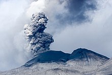
[78] Since then, the volcano has been continuously active[88] with numerous explosions every day, which produce volcanic ash clouds that can rise to elevations of 3.5 km (2.2 mi).
[89] A persistent gas plume lies above the volcano and repeated emissions of ash have happened, resulting in several alerts for the local population.
[90] A lava dome began to grow in 2017 within the crater, with unsteady explosive activity and occasional seismic swarms,[91] and was progressively destroyed in 2020.
Rock fall would affect the area close to the summit domes, as would pyroclastic flows; these would be a further hazard to the valleys draining the volcano.
[29] Other dangers from eruptions at Sabancaya are tephra fallout, which can impact the health of people,[106] animals and plants more than 50 kilometres (31 mi) away;[107] and lava flows, which however are not much of a threat to humans owing to their slow speed.
[108] Aside from the direct threat of eruptions, Sabancaya also contributes to SO2 air pollution in the Colca valley, which can damage plants and cause respiratory distress in animals and humans.
Annual precipitation east of the volcano is about 480–926 millimetres (18.9–36.5 in);[127] on average, about 2 metres (6 ft 7 in) ice and snow accumulate on Sabancaya during the wet season.
[33] The vegetation includes bushes, cacti, Festuca and Stipa (ichu) genera, tolar and yareta.
[133] Volcanic activity is visible from the Chivay-Arequipa road at Patapampa,[134] other viewpoints are at Mucurca northwest and Coporaque northeast of the volcano.