Sabine River (Texas–Louisiana)
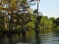
Along much of its lower reaches, it flows through pine forests along the Texas–Louisiana border, and eventually the bayou country near the Gulf Coast.
The combined river flows southeast across northeast Texas and is joined by a fourth branch, Lake Fork Creek, 70.0 miles (112.7 km) downstream from the reservoir.
South of the reservoir, it passes through the bayou country, surrounded by wetlands, as well as widespread industrial areas near the Gulf Coast.
The city of Port Arthur, Texas, sits along the western shore of Sabine Lake Archeological evidence indicates the valley of the river has been inhabited for as long as 12,000 years by indigenous peoples.
Starting in the eighth century, the Caddo inhabited the area, building extensive earthwork mounds in complexes expressing their cosmology.
The river was named in 1716 by Spanish explorer Domingo Ramón, and appeared as Río de Sabinas on a 1721 map.
After acquiring the French territory west of the Mississippi River in 1803 Louisiana Purchase, the United States started to exert control in this area.
Recorded ferry use began 1794, when Louis Chabinan (Sharben), his wife Margarite LaFleur, and their four children settled on the east bank of the Sabine River on land purchased from Vicinte Michele.
Various Spanish maps had errors in the naming of the Sabine and Neches and sometimes showed them flowing independently into the Gulf of Mexico.
After the Louisiana Purchase by the United States in 1803, a dispute over the boundary between the U.S. and Spain led to a demilitarized zone agreement on November 6, 1806, negotiated by Gen. James Wilkinson[21] and Lt. Col. Simón de Herrera,[22] to establish a neutral territory on both sides of the river.
[27][28] During the American Civil War, on September 8, 1863, a small Confederate force thwarted a Union invasion of Texas at the Second Battle of Sabine Pass, fought at the mouth of the river.
The discovery of petroleum at nearby Spindletop led to the river basin becoming the scene of widespread oil drilling.
The lower river, south of Orange to Sabine Lake, forms part of the Intracoastal Waterway, carrying barge traffic and some pleasure boats.
[30] The 1970 Louisiana Legislature passed Acts 90 and 117, creating the Sabine River Diversion Canal, for the purpose of supplying fresh river water to businesses in Lake Charles, Sulphur, Westlake, and what was Mossville (now the Sasol complex), as well as to farmers along the canal, with a total capacity of 216,000,000 US gallons (820,000,000 L; 180,000,000 imp gal) a day.
The canal is piped under Louisiana Highway 108, at pumping station #4, providing river water to the business area known as City Service in Westlake, and companies such as Equistar, which has a daily contract for 734,400 gallons a day.
Other customers and their gallons of use per day are the city of Westlake (8,640,000 gallons), Air Liquide (129,600), Air Products (1,728,000), CITGO (20,160,000), Phillips 66 (3,600,000), The Axiall subsidiary Eagle US 2 LLC (20,160,000), Entergy (21,600,000), Lake Charles Co-Gen (14,400,000), Louisiana Pigment (3,038,400) that produces Titanium White, another LyondellBasell company (720,000), and Matheson Tri-Gas (175,680).
[33] Up to 450,000 gallons (about 11,000 bls) of crude oil spilled over the Sabine River when the tanker Eagle Otome, which was carrying the shipment, struck two chemical-carrying barges due to loss of engine power on January 24, 2010, at 10 am local time.
[34] Severe flooding during the first week of March 2016 was the result of record rainfalls in northern Louisiana and the Sabine River basin, of 18 to more than 24 inches.
[37] A group of Texas residents who suffered damage in the flooding met March 17, 2016, to discuss a class-action suit against the Sabine River Authority (SRA), based on their belief that it had mismanaged water release.
[39] The SRA of Texas states, "The Authority was created as a conservation and reclamation district with responsibilities to control, store, preserve, and distribute the waters of the Sabine River and its tributary streams for useful purposes."
The site also states, "Toledo Bend Project-since its inception and original development over 50 years ago-has never been a flood-control facility.