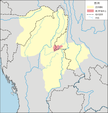
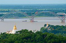
Sagaing Region
[citation needed] After the fall of Pagan in 1287, the northwestern parts of Upper Myanmar came under the Sagaing Kingdom (1315–1364) ruled by Burmanized Shan kings.
[citation needed] In the aftermath of the 2021 Myanmar coup d'état, Sagaing Region, which is part of the Bamar homeland, emerged as a stronghold of resistance against military rule.
Myanmar Armed Forces have engaged in significant military offensives throughout the region to quell resistance and intimidate local villagers.
[5][6] As of 2022, Sagaing Region consists of 13 districts and 1 Self-Administered Zone divided into 34 townships[7] with 198 wards and villages.
The major cities are Sagaing, Shwebo, Monywa, Ye U, Katha, Kale, Tamu, Mawlaik and Hkamti.
In August 2010,[8] three former townships of Hkamti District were transferred, in accordance with the 2008 constitution,[9] to a new administrative unit, the Naga Self-Administered Zone.
There are also an unknown number of Catholic Bayingyi people (at least 3,000), the descendants of 16th and 17th century Portuguese adventurers and mercenaries, who live in their ancestral villages on the expansive plains of the Mu River valley.
[11] Minority religious communities include Christians (6.6%), Muslims (1.1%), and Hindus (0.1%) who collectively comprise the remainder of Sagaing Region's population.
Industry includes textiles, copper refining, gold smelting, and a diesel engine plant.
Since the 2021 Myanmar coup d'état, illegal logging of teak and tamalan trees has surged in Sagaing Region, predominantly in key contested battlegrounds, including Kani, Yinmabin, Kantbalu, Indaw and Banmauk townships.
The military government spends anywhere from 0.5% to 3% of the country's GDP on health care, consistently ranking among the lowest in the world.
[20][21] Although healthcare is nominally free, in reality, patients have to pay for medicine and treatment, even in public clinics and hospitals.