Saguaro National Park
Earlier residents of and visitors to the lands in and around the park before its creation included the Hohokam, Sobaipuri, Tohono O'odham, Apaches, Spanish explorers, missionaries, miners, homesteaders, and ranchers.
In 1933, President Herbert Hoover used the power of the Antiquities Act to establish the original park, Saguaro National Monument, in the Rincon Mountains.
Popular activities in the park include hiking on its 165 miles (266 km) of trails and sightseeing along paved roads near its two visitor centers.
According to the United States Department of Agriculture, the Plant Hardiness zone at Red Hills Visitor Center 2,553 feet (778 m) is 9b with an average annual extreme minimum temperature of 25.8 °F (−3.4 °C), and 9a with an average annual extreme minimum temperature of 23.4 °F (−4.8 °C) at Rincon Mountain Visitor Center 3,091 feet (942 m).
Much later, about 600 million years ago, shallow seas covered the region around present-day Tucson; over time that led to deposition of sedimentary rocks—limestones, sandstones, and shales.
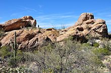
[35] Examples include large breccia exposed at Grants Pass and a granitic remnant of the magma chamber, which is visible from the Sus Picnic Area in the Tucson Mountain District.
[41] The Hohokam hunted deer and other animals, gathered cholla buds, prickly pears, palo verde pods, and saguaro fruit, and grew corn, beans, and squash.
Subsequent indigenous cultures, the Sobaipuri of the Tucson Basin and the Tohono O'odham to the west, may be descendants of the Hohokam,[42] though the evidence is inconclusive.
[42] Non-native settlement of the region near the park did not occur until 1692 with the founding of San Xavier Mission along the Santa Cruz River,[42][44] which flowed through Tucson.
[42] The lands that eventually would become Saguaro National Park remained relatively free of development until the mid-19th century, after Arizona had become part of the United States.
[47] The defunct Loma Verde Mine, which is still visible in the Rincon Mountain District,[42] produced a small amount of copper and gold between 1897 and 1907.
[48] Mining of igneous rock at 149 sites in the Tucson Mountain District sometimes produced ores of modest value in the late 19th and early 20th centuries.
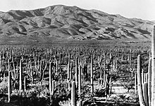
[52] In 1920 members of the Natural History Society of the University of Arizona expressed interest in establishing a protected area for saguaro, a cactus species familiar to watchers of silent-movie Westerns.
In 1928 Homer L. Shantz, a plant scientist and the university's president, joined the efforts to create a saguaro sanctuary,[53] but issues related to funding and management delayed the creation of a park.
In 1933 Frank Harris Hitchcock, publisher of the Tucson Citizen and a former United States Postmaster General who was influential in the Republican Party, persuaded U.S. President Herbert Hoover to create Saguaro National Monument.
[55][56] Later that year President Franklin D. Roosevelt transferred management of the monument, east of Tucson in the Rincon Mountains, to the National Park Service.
[53] Between 1936 and 1939, during the Roosevelt administration, the Civilian Conservation Corps (CCC) built the monument's Cactus Forest Loop Drive and related infrastructure.
[53] In 1961 President John F. Kennedy—encouraged by Stewart Udall, an Arizonan who was then Secretary of the Interior—added 16,000 acres (6,500 ha) of cactus lands in the Tucson Mountains to the monument.
Between 1933 and 1941 CCC workers built structures at eight picnic areas in the county-park portion of the set-aside, five of which later became part of the Tucson Mountain District of the national monument.
[66] Invasive plants include fountain grass, tamarisk, Malta starthistle, and many others, but by far the most severe threat to the native ecosystem is buffelgrass.
The noxious weed, considered impossible to eliminate, is managed in some areas of the park and in Tucson residential zones by hand-pulling and, during periods of wet weather, application of glyphosate-based herbicides.
[71] The wide range of habitats in the park supports a diverse population of birds, including some that are uncommon elsewhere in the United States, such as the vermilion flycatcher and the whiskered screech owl.
[76] Forest fires, which create erosion-prone burned areas, have destroyed many of the leopard frog's breeding pools, which fill with sediment.
[79] These ranges resemble a series of stepping stones between the southern end of the Rocky Mountains—specifically the Mogollon Rim of the Colorado Plateau—in the United States and the Sierra Madre Occidental in Mexico.
[81] More than 165 miles (266 km) of hiking trails wind through the park,[82] where perils may include extreme heat, dehydration, flash floods, cactus spines, snakes, cougars, bears, and Africanized bees.
[89] Among the notable artificial structures in the Tucson Mountain District are ramadas, picnic tables, and restrooms built by the Civilian Conservation Corps between 1933 and 1941.
Designed to conform to their natural surrounds, the rustic buildings consist mainly of quarried stone and other materials native to the area.
The non-profit organization, operating on 98 acres (40 ha) rented from Pima County, combines aspects of a botanical garden, zoo, and natural history museum featuring the plants and animals native to the region.
[87][88] Manning Camp Campground is the main staging area for firefighters, trail-maintenance crews, and scientists working in the Rincon Mountain District.
[94] The Sonoran Desert Inventory and Monitoring Network of which the DRLC is part, covers 10 national monuments or parks in Arizona and one in New Mexico.