St Helier
Evidence of settlement exists as far back as the 13th century, and the growth of the town since has been described as "spasmodic", its expansion reflecting the waves of migration to the island.
The medieval hagiographies of Helier, the patron saint martyred in Jersey and after whom the parish and town are named, suggest a picture of a small fishing village on the dunes between the marshy land behind and the high-water mark.
Closed at the Reformation, the site of the abbey was fortified to create the castle that replaced Mont Orgueil as the island's major fortress.
This establishment of Christianity as the principal religion of the islanders brought with it new governmental structures by the end of the 10th century, including the parochial system.
[6] Although it is now some considerable distance from the sea, at the time of its original construction it was on the edge of the dunes at the closest practical point to St Helier's Hermitage.
Regular markets were held in the town from at least the 15th century and the Royal Court is recorded to have sat in St Helier from ancient times.
A 1563 map shows a group of buildings huddled behind the town church, with an axis - likely either King Street or the Royal Square - through the centre.
At this time, the line of King Street ("rue de Derrière") and Queen Street ("rue du Milieu") were established, extending from Charing Cross ("la Pompe du bas", the outlet of Le Grand Douet) and Snow Hill ("Pompe de haut").
[6] Improvements to take place during the 17th century included the walling of the Town Church cemetery, the construction of a prison (which arched over Charing Cross) and the paving of important streets.
The Town is inhabited chiefly by merchants, shop-keepers ... and retailers of liquors; the landed gentlemen generally living upon their estates in the country.
Besides the stream running through the place [and literally under some houses] there is farther supply of good water from wells and pumps.George II gave £200 towards the construction of a new harbour – previously boats would be beached on a falling tide and unloaded by cart across the sands.
[6] As harbour construction moved development seaward, a population growth meant that marshland and pasture north of the ribbon of urban activity was built on speculatively.
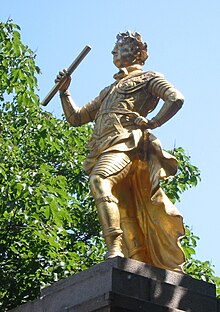
Continuing military threats from France spurred the construction of a citadel fortress, Fort Regent, on the Mont de la Ville, the crag dominating the shallow basin of St Helier.
[6] Military roads linking coastal defences around the island with St Helier harbour allowed farmers to exploit Jersey's temperate micro-climate and use new fast sailing ships and then steamships to get their produce to the markets of London and Paris before the competition.
This new immigration had a large impact on local architecture, with a number of mainland Georgian-style houses and terraces erected on the main roads out of the town.
The town's expansion mainly happened in the semi-saucer of flat land between Westmount and Mount Pleasant, so there remained a significant rural part of the parish.
Pressure for redevelopment has meant that very few buildings remain in urban St Helier which date to before the 19th century, giving the town primarily a Regency or Victorian character.
After the First World War, the need for new homes could not be met in the confines of the basin, and with the growth of the motorcar, the roads leading out into the country allowed ribbon development in all directions, along the coast, up over the hills and into neighbouring parishes.
[6] After the German occupation of the Channel Islands, St Helier continued to change as a result of renewed tourism industry and Jersey's role as a financial centre.
A large change was the unprecedented movement of people around the island thanks to the motor car, which required higher capacity on the old road network and more parking.
A heritage architecture preservation movement grew, partly due to the destruction of a number of historic buildings in the Hue/Dumaresq Street area.
[6] About the same time, Fort Regent was converted into a major leisure facility and was linked to the town centre by a gondola cableway, which was closed and demolished in the 1990s.
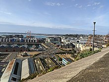
[7] In the southeast of the parish, rising from the plains in the centre of town is Mont de Ville and Mount Bingham which divide the Havre des Pas district from the Harbour.
[24] Winters on the island tend to be milder than in both mainland Britain and Continental Europe, being greatly influenced by the surrounding ocean and the Gulf stream.
As the island is more subject to influence from the azores high, and the ocean prevents convectional percipitaion, rainfall is plentiful in autumn-winter but modest in late spring and summer with July being the driest month.
Sunshine hours are noticeably higher than in mainland UK and northern France averaging nearly 2100 pr year compared to 1650 in London or Paris .
In 1842, due to the rising population of St Helier, the Dean of Jersey raised money to replace the church with a larger building; however, it was never built.
The plan aims to improve safety and convenience for pedestrians across La Route de la Libération (which is a road that runs through the area and is grade separated and at some points six lanes wide), including the possibility of an 'iconic bridge'; require major development proposals to have detailed landscaping schemes to enhance open space and secure a mix of uses in the area, including community facilities.
[55] The state-owned Jersey Development Company, which owns much of the land in the area, is managing the redevelopment and has contracted Gillespies, a landscape architecture firm, after a concept design competition.
Motorsports events take place on roads in the Parish as well as an annual Town Criterium, and the start and finish of the Jersey Marathon.